Items Similar to Antique Map of the World on Mercator Projection by Anson, 1749


Want more images or videos?
Request additional images or videos from the seller
1 of 6
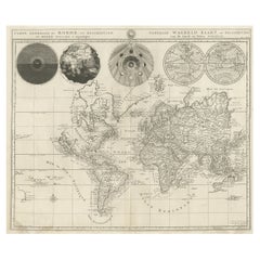
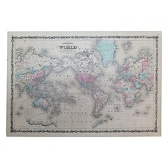
Antique Map of the World on Mercator Projection by Anson, 1749
About the Item
Antique map titled 'Nieuwe Wereld Kaart waar in de Reizen van den Hr. Anson rondsom de Wereld'. Original antique map of the world on Mercator's Projection from a Dutch edition of Anson's voyages. The map includes California as an Island, an incomplete Australia which connects to New Guinea, no Southern Hemisphere, Northwest passage, no New Zealand and a host of other cartorgraphic misconceptions. Shows Anson's tracks around the world. This map originates from 'Reize rondsom de Werreld (..)' by George Anson, published 1749.
Artists and Engravers: Admiral of the Fleet George Anson, 1st Baron Anson, PC, FRS (23 April 1697 – 6 June 1762) was a Royal Navy officer.
Condition: Good, general age-related toning. Original folding lines. Minor wear, some foxing. Blank verso, please study image carefully.
We sell original antique maps to collectors, historians, educators and interior decorators all over the world. Our collection includes a wide range of authentic antique maps from the 16th to the 20th centuries. Buying and collecting antique maps is a tradition that goes back hundreds of years. Antique maps have proved a richly rewarding investment over the past decade, thanks to a growing appreciation of their unique historical appeal. Today the decorative qualities of antique maps are widely recognized by interior designers who appreciate their beauty and design flexibility. Depending on the individual map, presentation, and context, a rare or antique map can be modern, traditional, abstract, figurative, serious or whimsical. We offer a wide range of authentic antique maps for any budget.
- Dimensions:Height: 10.63 in (27 cm)Width: 16.74 in (42.5 cm)Depth: 0 in (0.01 mm)
- Materials and Techniques:
- Period:
- Date of Manufacture:1749
- Condition:Condition: Good, general age-related toning. Original folding lines. Minor wear, some foxing. Blank verso, please study image carefully.
- Seller Location:Langweer, NL
- Reference Number:Seller: BG-11589-131stDibs: LU3054329302492
About the Seller
5.0
Platinum Seller
These expertly vetted sellers are 1stDibs' most experienced sellers and are rated highest by our customers.
Established in 2009
1stDibs seller since 2017
1,965 sales on 1stDibs
Typical response time: <1 hour
- ShippingRetrieving quote...Ships From: Langweer, Netherlands
- Return PolicyA return for this item may be initiated within 14 days of delivery.
Auctions on 1stDibs
Our timed auctions are an opportunity to bid on extraordinary design. We do not charge a Buyer's Premium and shipping is facilitated by 1stDibs and/or the seller. Plus, all auction purchases are covered by our comprehensive Buyer Protection. Learn More
More From This SellerView All
- Antique Map of the World on Mercator's Projection, 1788Located in Langweer, NLAntique map titled 'Kaart van de Geheele Wereld (..)'. Uncommon small world map on Mercator's projection. Nice detail of the islands throughout the wor...Category
Antique Late 18th Century Maps
MaterialsPaper
- Antique Map of the World, Mercator Projection, by Wyld, '1845'Located in Langweer, NLAntique map titled 'The World'. Original antique world map, on Mercator's projection. This map originates from 'An Atlas of the World, Compr...Category
Antique Mid-19th Century Maps
MaterialsPaper
- Colorful Detailed Antique Map of The World on Mercators Projection, 1882Located in Langweer, NLThe 'World of Mercator's Projection' is a map with a stunning portrayal of global geography and maritime navigation from an era steeped in exploration and discovery. With meticulous detail and precision, this map showcases the world's continents on Mercator's famous projection, capturing the essence of a bygone era's cartographic expertise. Illustrating the courses of chief ocean currents and key navigation tracks between major ports, this map doesn't just depict landmasses but also reveals the vital maritime routes that shaped global trade and exploration. Each line and curve represents the pathways of ancient voyages and modern seafaring, connecting distant shores and continents. Crafted with the precision characteristic of Mercator's projection, this map offers a unique perspective on how sailors and explorers navigated the world's vast oceans. It stands as a testament to the artistry and scientific ingenuity of cartographers of that time, showcasing their commitment to accurate representation amid the challenges of mapping a spherical world on a flat surface. This map isn't just a historical document; it's a captivating piece of cartographic art...Category
Antique 1880s Maps
MaterialsPaper
- Antique Mercator Projection World Map by Petri, c.1873Located in Langweer, NLAntique world map titled 'Wereldkaart naar Mercator's Projectie'. Old map of the world. This map originates from 'School-Atlas van alle Deelen der Aarde'. Artists and engravers: ...Category
Antique 19th Century Maps
MaterialsPaper
- Antique Detailed World Map Drawn on Mercator's Projection, 1700Located in Langweer, NLAntique world map titled 'Carte generale du monde, ou description du monde terrestre & Aquatique - Generale Waereld kaart, of beschryving van de land en water waereld'. This is Pierr...Category
Antique 17th Century Maps
MaterialsPaper
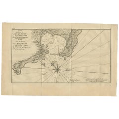
- Antique Map of the Port of Zihuatanejo by Anson '1749'Located in Langweer, NLAntique map titled 'Plan du Port de Chequetan ou Seguataneo - Plan van de Haven van Chequetan of Seguataneo'. Map of the Mexican port of Zihuatanejo. This area was originally named C...Category
Antique Mid-18th Century Maps
MaterialsPaper


You May Also Like
- 1864 Johnson's Map of the World on Mercator's Projection, Ric.B009Located in Norton, MAAn 1864 Johnson's map of the World on Mercator's Projection Ric.b009 About this Item "This antique map came from Johnson's New Illustrated (Steel Plate) Family Atlas, publ...Category
Antique 19th Century Dutch Maps
MaterialsPaper
- Colored wall map of the WORLDBy ChambonLocated in ZWIJNDRECHT, NL“Mappe Monde, contenant les Parties Connues du Globe Terrestre” CHAMBON, Gobert-Denis (France, 17.. - 1781) Paris, Longchamps et Janvier, 1754 Size H. 115 x W. 145 cm. Gobert-Denis Chambon made copper engraving after the work of Guillaume De L’Isle, published in 1754 by Jean Janvier and S.G. Longschamps. A huge wall map of the world in two hemispheres printed on two sheets, depicting the Eastern and Western hemispheres supported by two male figures, decorated at the bottom right and left with two celestial hemispheres (boreal and southern) and at the bottom in the middle with an armillary sphere, in addition. This map is most notable for its depiction of the Sea of Japan labeled "Mer de Corée" and of "Mer de L'Ouest" or Sea of the West - a great sea, easily the size of the Mediterranean, to flow from the then-known Strait of Juan de Fuca...Category
Antique Mid-18th Century French French Provincial Maps
MaterialsWood, Paper

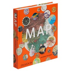
- Map, Exploring The WorldLocated in New York, NY300 stunning maps from all periods and from all around the world, exploring and revealing what maps tell us about history and ourselves. Selected by an international panel of cartographers, academics, map dealers and collectors, the maps represent over 5,000 years of cartographic innovation drawing on a range of cultures and traditions. Comprehensive in scope, this book features all types of map from navigation and surveys to astronomical maps, satellite and digital maps, as well as works of art inspired by cartography. Unique curated sequence presents maps in thought-provoking juxtapositions for lively, stimulating reading. Features some of the most influential mapmakers and institutions in history, including Gerardus Mercator, Abraham Ortelius, Phyllis Pearson, Heinrich Berann...Category
21st Century and Contemporary Hong Kong Books
MaterialsPaper
- 1625 Mercator Map of the Provenience of Quercy, "Quercy Cadvrcivm Ric.0013Located in Norton, MA1625 Mercator map of the provenience of Quercy, entitled "Quercy Cadvrcivm," Ric.0013 " Authentic" - Map of the provenience of Quercy Cadvrcivm D...Category
Antique 17th Century French Maps
MaterialsPaper
- Map Exploring The World, Midi FormatLocated in New York, NYA compelling exploration of the ways that humans have mapped the world throughout history - now in a compact new edition Map: Exploring the World brings together more than 250...Category
21st Century and Contemporary Books
MaterialsPaper
- 17th Century Hand-Colored Map of West Africa by Mercator/HondiusLocated in Alamo, CAA 17th century hand-colored map entitled "Guineae Nova Descriptio" by Gerard Mercator and Jodocus Hondius, published in their 'Atlas Minor' in Amsterdam in 1635. It is focused on the...Category
Antique Mid-17th Century Dutch Maps
MaterialsPaper


Recently Viewed
View AllMore Ways To Browse
18th Century Southern Antiques
California Map
Antique Furniture New Zealand
Dutch Navy
New Zealand Antique Furniture
Van Host
California As An Island Map
Antique Caribbean Maps
Antique Furniture Durham
Antique Furniture Tasmania
Antique Maps Caribbean
Large Antique Maps North America
Map Of Peru
Philippines Map
Sri Lanka Map
Victor Levasseur On Sale
Antique Map Of Caribbean
Antique Map Of The Caribbean