Items Similar to Colored wall map of the WORLD


Want more images or videos?
Request additional images or videos from the seller
1 of 20
Colored wall map of the WORLD
About the Item
“Mappe Monde, contenant les Parties Connues du Globe Terrestre”
CHAMBON, Gobert-Denis (France, 17.. - 1781)
Paris, Longchamps et Janvier, 1754
Size H. 115 x W. 145 cm.
Gobert-Denis Chambon made copper engraving after the work of Guillaume De L’Isle, published in 1754 by Jean Janvier and S.G. Longschamps.
A huge wall map of the world in two hemispheres printed on two sheets, depicting the Eastern and Western hemispheres supported by two male figures, decorated at the bottom right and left with two celestial hemispheres (boreal and southern) and at the bottom in the middle with an armillary sphere, in addition.
This map is most notable for its depiction of the Sea of Japan labeled "Mer de Corée" and of "Mer de L'Ouest" or Sea of the West - a great sea, easily the size of the Mediterranean, to flow from the then-known Strait of Juan de Fuca. Australia and New Zealand are depicted in typical post-Tasman form, however, unlike other French cartographers at the time who tended to join New Guinea to Tasmania in a single and highly creative, imaginary coastline, Janvier leaves those undiscovered coastlines blank.
Early Dutch discoveries are noted in Australia and New Zealand, as are other recent discoveries worldwide. The tracks of Magellan, Vasco da Gama, and Francis Drake are shown. According to Don McGuirk, this map shows an early copy of a Buache type 1 Mer de l'Ouest.
Four states of this map were found.
- State 1: Dated 1751.
- State 2: Dated 1754. Under the title, engraved by "Chambon". Lower left, "A PARIS, chés les Sieurs Longchamps et Janvier, Geographes, rue St Jacques a l'Enseigne de la Place des Victoires." This state and later states is found surrounded by borders with biblical vignettes.
- State 3: Dated 1788. Now "chez Mondhare and Jean".
- State 4: Dated An 8 (1799-1800). Now "Paris Chez Jean rue Jean de Beauvois.
Reference: McGuirk, The Last Great Cartographic Myth - Mer de l'Ouest, 30 (Later colored. Some parts contemporarily underlaid with paper, for protective reason. Repair of a split on the crossing of folds. Some paper discoloration. Some staining and folds)
- Creator:Chambon (Maker)
- Dimensions:Height: 45 in (114.3 cm)Width: 57 in (144.78 cm)Depth: 0.8 in (2.04 cm)
- Style:French Provincial (Of the Period)
- Materials and Techniques:
- Place of Origin:
- Period:
- Date of Manufacture:1754
- Condition:Repaired: Some parts are contemporarily underlaid with paper, for protective reasons. Repair of a split on the crossing of folds. Wear consistent with age and use.
- Seller Location:ZWIJNDRECHT, NL
- Reference Number:1stDibs: LU9419237770662
About the Seller
No Reviews Yet
Vetted Seller
These experienced sellers undergo a comprehensive evaluation by our team of in-house experts.
1stDibs seller since 2023
- ShippingRetrieving quote...Ships From: ZWIJNDRECHT, Netherlands
- Return PolicyA return for this item may be initiated within 14 days of delivery.
More From This SellerView All
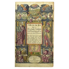
- Hand-colored 16th century copy of the famous Moerentorf BibleBy Henry MoretLocated in ZWIJNDRECHT, NLPublisher: Daniel Vervliet and Hendrik Swingen for Jan I Moretus & Jan I van Keerberghen Place / Date: Antwerp, 1599 Biblia sacra. Dat is de geheele heylighe schrifture bed...Category
Antique 16th Century Belgian Baroque Books
MaterialsWood, Paper
- Seminal guide to the East and West Indies, with 42 coloured maps and platesBy Jan Huygen van LinschotenLocated in ZWIJNDRECHT, NLSeminal guide to the East and West Indies, with 42 double-page and folding plates, including 6 maps, all engravings beautifully coloured by a contemporary hand LINSCHOTEN, Jan Huygh...Category
Antique Early 17th Century Dutch Dutch Colonial Books
MaterialsPaper
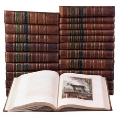
- Hand-coloured set of Buffon’s Histoire naturelle in its most luxurious formBy Georges-Louis Leclerc, Comte de BuffonLocated in ZWIJNDRECHT, NLPublisher: Buffon, Georges-Louis Leclerc de Place / Date: Dordrecht, Abraham Blussé, 1766-1799 Size: 38 parts in 21 volumes. Large 4to. With more than 1100 hand-coloured engraved ...Category
Antique Late 18th Century Dutch Dutch Colonial Books
MaterialsPaint, Paper
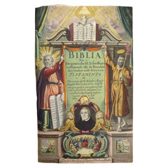
- Dutch Luther Bible with fine hand-coloured and highlighted in gold illustrationsBy Claes Jansz. Visscher (II)Located in ZWIJNDRECHT, NLBeautifully bound mid-17th-century "Visscher edition" of the Dutch Luther Bible with expertly hand-coloured and highlighted in gold illustrations. [BIBLE - LUTHER - DUTCH]. VISSCHER...Category
Antique 1640s Dutch Dutch Colonial Books
MaterialsGold
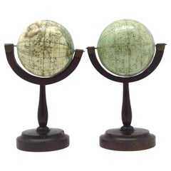
- A fine pair of miniature globes on standsBy Karl MullerLocated in ZWIJNDRECHT, NLA rare pair of miniature terrestrial and celestial globes. by K. Müller, 1822 Karlsruhe, Germany Diameter globes: 7 cm. Total high: 14,5 cm. Each with 12 hand-coloured engraved p...Category
Antique Early 19th Century German International Style Globes
MaterialsHardwood, Paper
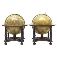
- An exceptional pair of BLAEU table globesBy Willem BlaeuLocated in ZWIJNDRECHT, NLA very rare set of globes, 9 inch / 23cm, with an overall height of 38 cm, Amsterdam, dated 1602, but published after 1621. In their original stands with circular wooden horizon rings, covered with printed paper, supported by four legs and brass meridian rings supported by a single column. The terrestrial and celestial globe are made up of a set of 12 engraved gores, heightened in gold and Arctic ice caps, printed on paper and mounted on a plaster sphere of papier maché. Each sphere is mounted in a graduated brass meridian ring with the production number stamped at the back of the ring. Both globes are mounted on four-legged ebonized oak Dutch stands, which support the horizon ring. The legs are connected by two crossbeams which support a circular base plate with central support for the meridian ring. The horizon rings are covered with printed paper. With usual defects: paper equinoctial tables present gaps that are filled and restored; small splits along gores; several partially deleted entries; on the globe, the date 1602 and the text of the cartouche in America, are illegible ; small scattered spots but in general in good condition for such an early globe pair of which presently only 19 pair are recorded. These 9-inch globes are among the rarest since very few copies of them are known to exist, in comparison with the smaller or larger globes of Blaeu (4, 6, 13.5, and 26 inches). Blaeu's terrestrial globes were highly valued and were much in demand, because of the care with which they had been prepared, because of the efforts to give the latest information on discoveries, and because of the loxodromic lines that made them of special value to navigators. His celestial globes were appreciated for the fact that he had been the pupil of Tycho Brahe, who was himself known to be the greatest astronomer of his time. Willem Janszoon Blaeu (1571–1638), originally trained in astronomy, he quickly became a leading maker of maps, atlases and instruments. Blaeu’s globes were luxury items for wealthy and intellectual merchants and nobility who benefited from Blaeu’s access through the Dutch East India Company to the latest navigational discoveries and geographical information. Willem Jansz Blaeu collected information that Dutch mariners gathered from around world and brought back to Amsterdam. Crews were instructed to record information about the lands they visited and the skies they saw. Blaeu incorporated these observations in maps and globes. Through his web of contacts and thanks to assiduous research, he was also able to obtain the most recent information about the latest discoveries in the western hemisphere and the South Pacific, where Dutch explorers were particularly active at the time. Since the globe was published after 1618, Blaeu was able to include the discoveries made by Henry Hudson in his attempt to find a passage to the East Indies. He also included recent Pacific discoveries of the celebrated voyages of Willem Cornelis Schouten and Jacob Le Maire, who both traversed the South Pacific and the Atlantic. The findings of Schouten and Le Maire in the Tierra del Fuego region are also incorporated. The Strait of Le Maire is drawn and the hypothetical southern continent is labelled “Terra Australis Incognita Magalanica”. Olivier van Noort’s track is drawn and labelled. His route is indicated with a broken line and the words: “Navigationis Olivierij ductus” (several times). There are various decorative features, such as animals on the different continents, many ships on the high seas and allegorical and mythical figures around the cartouches. The nine-inch globe is not just a smaller version of the one published in 1599. Drawings of animals and people do often correspond to those on the earlier globe, but Blaeu made several significant changes. - The west coast of North America is drawn differently and the river system of Brazil is altered. - The hypothetical southern continent is labelled: Terra Australis Incognita Magallanica. - There are nine ocean names in handsome curling letters: Mare Congelatum, Mare Atlanticum, Oceanus Aethiopicus, Mare Arabicum et Indicum, Mare di India, Oceanus Chinensis, Mar del Zur, Mare Pacificum, Mar del Nort. - Willem Blaeu...Category
Antique 17th Century European Dutch Colonial Globes
MaterialsOther

You May Also Like
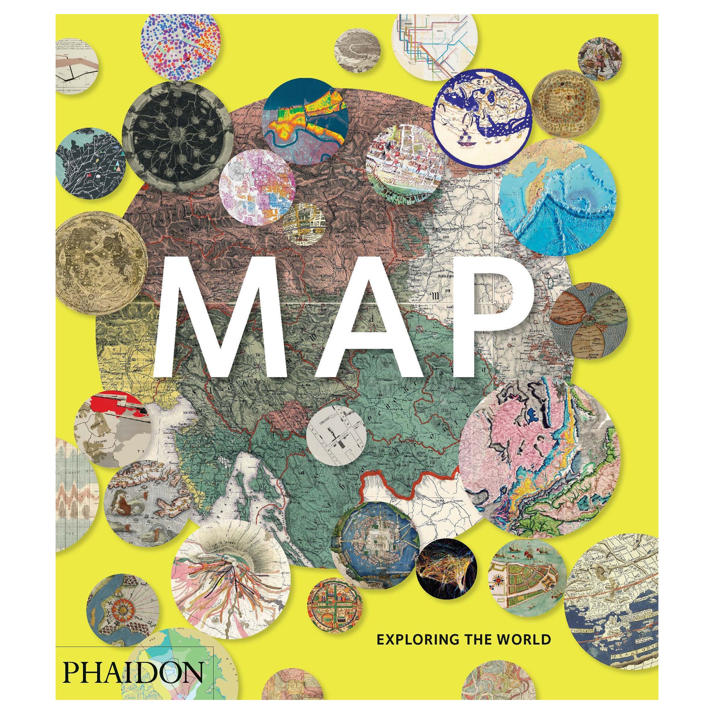
- Map, Exploring The WorldLocated in New York, NY300 stunning maps from all periods and from all around the world, exploring and revealing what maps tell us about history and ourselves. Selected by an international panel of cartographers, academics, map dealers and collectors, the maps represent over 5,000 years of cartographic innovation drawing on a range of cultures and traditions. Comprehensive in scope, this book features all types of map from navigation and surveys to astronomical maps, satellite and digital maps, as well as works of art inspired by cartography. Unique curated sequence presents maps in thought-provoking juxtapositions for lively, stimulating reading. Features some of the most influential mapmakers and institutions in history, including Gerardus Mercator, Abraham Ortelius, Phyllis Pearson, Heinrich Berann...Category
21st Century and Contemporary Hong Kong Books
MaterialsPaper
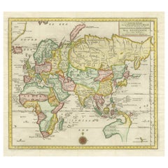
- Antique Map of the Eastern Part of the WorldLocated in Langweer, NLAntique map titled 'Nieuwe Kaart van het Oostelykste Deel der Weereld, diendende tot aanwyzing van de Scheepstogten der Nederlanderen Naar Oostindie'. This finely engraved map of the...Category
Antique Mid-18th Century Maps
MaterialsPaper
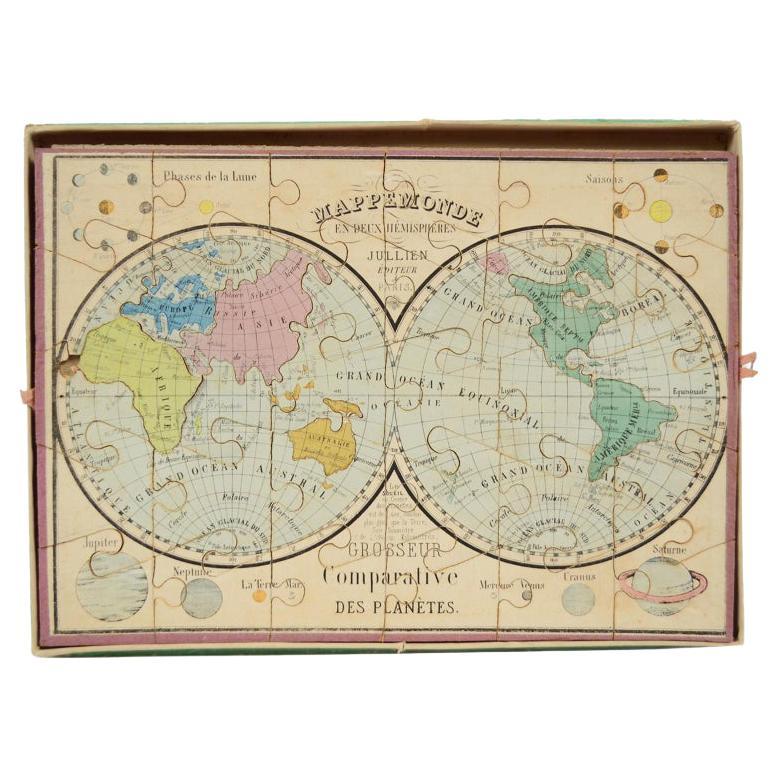
- Antique Puzzle of Colored Cardboard Depicting World Map, Europe and FranceLocated in Milan, ITEducational puzzle of colored cardboard composed of three folders depicting world map, Europe and France. The world map in addition to the territorial map of the continents depicts t...Category
Antique 1850s French Games
MaterialsPaper
- Antique Map of the World by Johnson, '1872'Located in Langweer, NLAntique map titled 'Johnson's World. Original world map. This map originates from 'Johnson's New Illustrated Family Atlas of the World' by A.J. John...Category
Antique Late 19th Century Maps
MaterialsPaper
- Antique Map of the World by Ferrario '1831'Located in Langweer, NLOriginal antique map of the world. This print originates from 'Costume Antico e Moderno: Palestine, China, India, Oceania' by Ferrario. Publis...Category
Antique Mid-19th Century Prints
MaterialsPaper
- Antique Map of the World by Balbi '1847'Located in Langweer, NLAntique map titled 'Planisphère'. Original antique map of the world. This map originates from 'Abrégé de Géographie (..)' by Adrien Balbi. Pub...Category
Antique Mid-19th Century Maps
MaterialsPaper


Recently Viewed
View AllMore Ways To Browse
World Map Wall
Wall Map Of The World
Antique Wall Maps Of The World
French Wall Map
Wall Map Of France
Japanese Labels
Mid Century Globe World
Wall World Globes
Antique New Zealand
Hand Colored Copper Engraving
Eastern Antiques
Southern Antiques
Antique Furniture New Zealand
New Zealand Antique Furniture
Wood Furniture 1800w
Australian Antiques
Celestial Globe
Antique Celestial Globe