Items Similar to L'isle De La Martinique Caribbean Copper Engraving Original Handcoloring, 1704
Want more images or videos?
Request additional images or videos from the seller
1 of 6
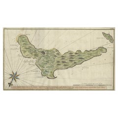
L'isle De La Martinique Caribbean Copper Engraving Original Handcoloring, 1704
About the Item
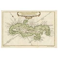
The original hand-colored map titled "Isle de la Martinique," published in 1704 and part of De Fer's Atlas Curieux, is a cartographic masterpiece offering an intricate portrayal of the island of Martinique during that era.
**Title:** Isle de la Martinique
**Publisher:** De Fer, Atlas Curieux
**Date:** 1704
This map presents a remarkably detailed and comprehensive view of Martinique, showcasing the island's topography, geographical features, and various points of interest. Noteworthy elements include:
1. **Orientation:** The map is oriented with east at the top, providing a unique perspective for exploration and navigation.
2. **Geographical Features:** It meticulously outlines the island's landscape, including rivers, mountains, bays, harbors, and smaller surrounding islands. The representation of these features offers insights into the terrain and natural formations of Martinique.
3. **Settlements and Infrastructure:** The map showcases forts, churches, towns, and anchorages across the island. These markers indicate the strategic, religious, and residential areas of significance during that period.
4. **Key and Points of Interest:** An extensive key accompanies the map, listing over 60 specific points of interest. This key provides additional information about important landmarks, historical sites, or other notable features on the island, enriching the map's informational value.
De Fer's Atlas Curieux was celebrated for its detailed and accurate cartography, and this map of Martinique exemplifies the precision and thoroughness characteristic of the atlas. It serves as a valuable historical document, offering not just geographical information but also insights into the cultural, strategic, and natural aspects of Martinique in the early 18th century.
The original hand-coloring further enhances the map's visual appeal and distinguishes between different geographical elements, adding to its artistic and historical significance. This map remains a treasure, providing a window into the past, allowing viewers to explore and understand Martinique's landscape and important landmarks as they were perceived centuries ago.
VERSO: There is nothing printed on the reverse side, which is plain
AUTHENTICITY: This is an authentic historic print, published at the date stated above. I do not offer reproductions. It is not a modern copy. The term 'original' when applied to a print means that it was printed at the first or original date of publication; it does not imply that the item is unique. 'Print' means any image created by applying an inked block to paper or card under pressure by any method including wood engraving, steel engraving, copperplate, wood cut and lithography.
- Dimensions:Height: 10.63 in (27 cm)Width: 15.56 in (39.5 cm)Depth: 0 in (0.02 mm)
- Materials and Techniques:Paper,Engraved
- Period:
- Date of Manufacture:1876
- Condition:Good; suitable for framing. Some light creases and dirt due to handling. Colored by hand at the time of publication. Most antiquarian maps and prints are subject to some normal aging due to use and time which is not obtrusive unless otherwise stated.
- Seller Location:Langweer, NL
- Reference Number:
About the Seller
5.0
Platinum Seller
These expertly vetted sellers are 1stDibs' most experienced sellers and are rated highest by our customers.
Established in 2009
1stDibs seller since 2017
1,965 sales on 1stDibs
Typical response time: <1 hour
- ShippingRetrieving quote...Ships From: Langweer, Netherlands
- Return PolicyA return for this item may be initiated within 14 days of delivery.
More From This SellerView All
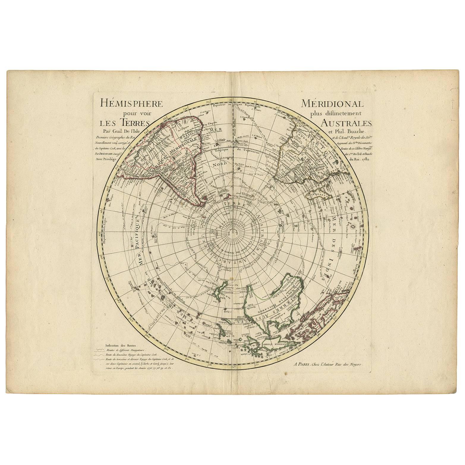
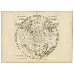
- 18th Century Antique Engraving of the Southern Hemisphere by G. de L'IsleBy Guillaume De L'IsleLocated in Langweer, NLAntique map titled 'Hemisphere Meridional pour voir plus distinctement Les Terres Australes'. Hemispherical map of the southern hemisphere centered on ...Category
Antique Late 18th Century Maps
MaterialsPaper
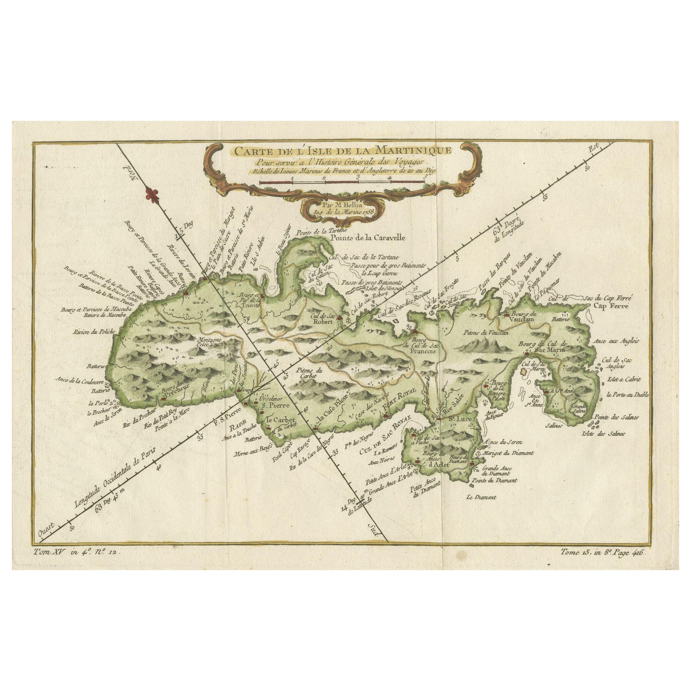
- Martinique Island in the Caribbean by Bellin Original Original Antique Map, 1780Located in Langweer, NLThis mid-18th century map, "Carte de l'Isle de la Martinique pour servir a l'historie generale des voyages," was issued in 1780 by M. Bellin in Paris. It presents a detailed and visually captivating depiction of the Island of Martinique within the context of the Caribbean and the Lesser Antilles. **Title:** Carte de l'Isle de la Martinique pour servir a l'historie generale des voyages **Issuer:** M. Bellin **Date:** 1780 **Location Coverage:** North America, Caribbean, Martinique, Lesser Antilles This engraved map is notable for its pleasing aesthetics, featuring lovely hand coloring that enhances its visual appeal. The inclusion of a scroll cartouche, an ornamental frame, and measurement lines adds a distinctive and visually appealing quality to the map. Martinique, situated within the Lesser Antilles in the Caribbean, is presented with meticulous detail, showcasing geographical features, coastlines, settlements, and other notable landmarks. Bellin, known for his accuracy in cartography, crafted this map to serve as a geographical reference within the broader context of historical voyages and exploration. The combination of detailed cartographic information and artistic embellishments, such as hand coloring and decorative elements, makes this map not only a valuable geographical document but also a visually pleasing piece of cartographic art...Category
Antique Late 18th Century Maps
MaterialsPaper
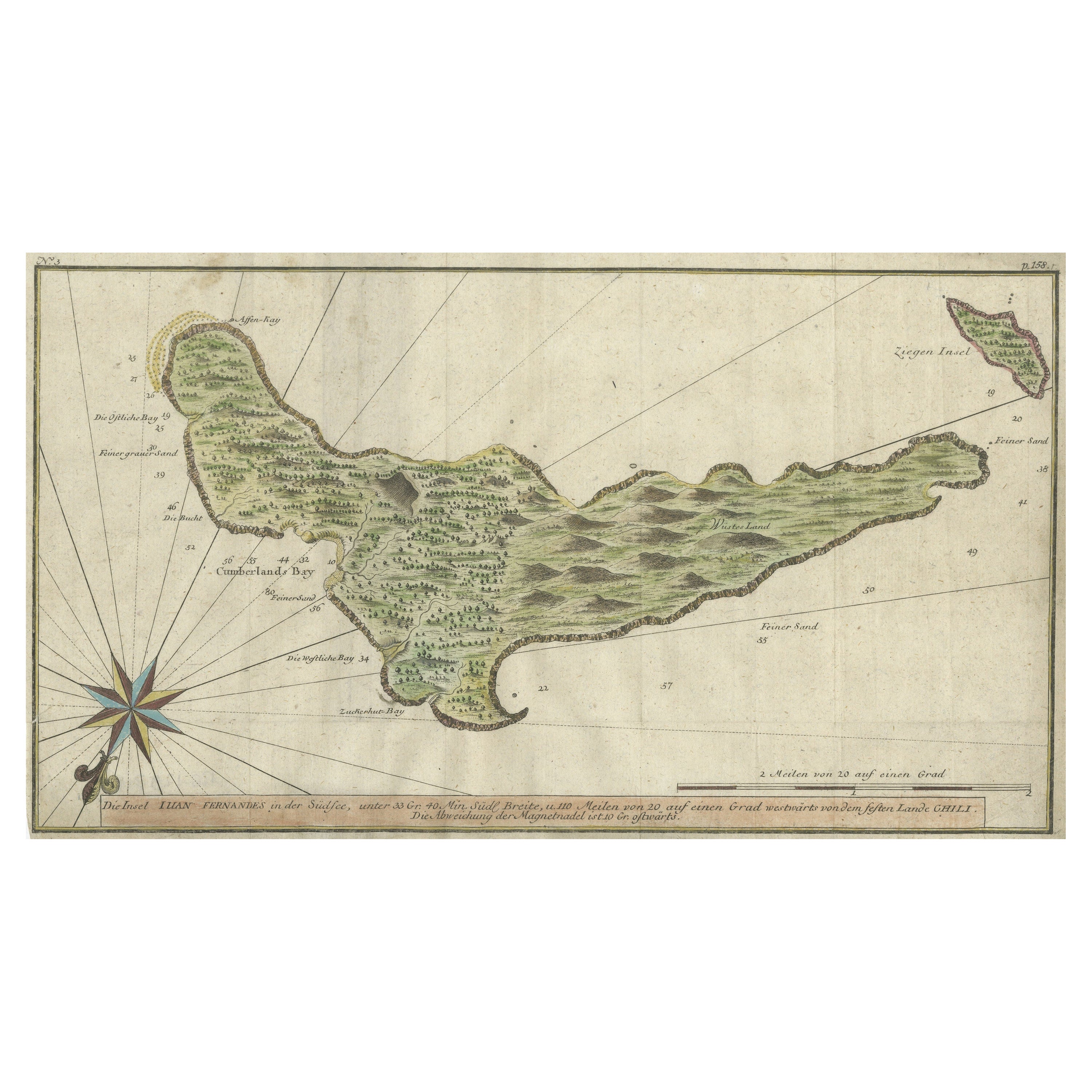
- Rare Handcolored Map of Isle de Juan Fernandes 'Robinson Crusoe Island', ChiliLocated in Langweer, NLAntique map titled 'Die Insel Iuan Fernandes in der Sudsee (..)'. This map depicts Robinson Crusoe, one of the Juan Fernández Islands. Robinson Crusoe Island, formerly known as Más a Tierra, is the second largest of the Juan Fernández Islands. From 1704 to 1709, the island was home to the marooned sailor Alexander Selkirk, who at least partially inspired novelist Daniel Defoe's fictional Robinson Crusoe in his 1719 novel, although the novel is explicitly set in the Caribbean. This was just one of several survival stories from the period of which Defoe would have been aware. To reflect the literary lore associated with the island and attract tourists, the Chilean government renamed the place Robinson Crusoe Island in 1966. This map originates from a German edition of 'Voyage around the World...Category
Antique Mid-18th Century Maps
MaterialsPaper
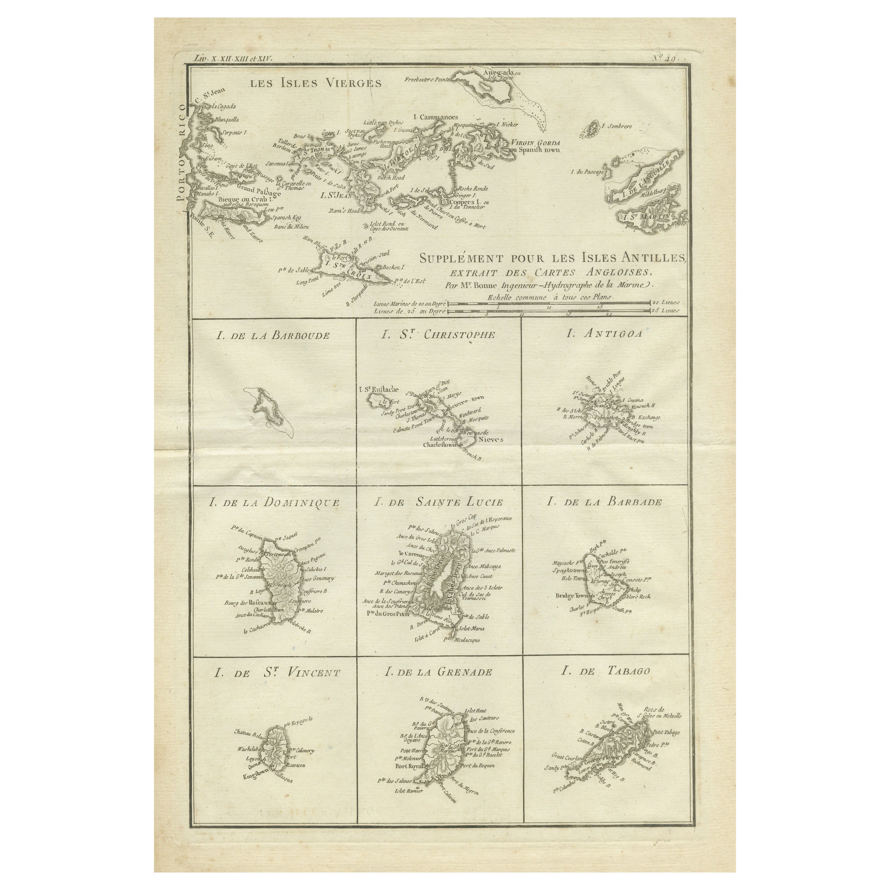
- Original Antique Map of the Virgin Islands with Insets of Caribbean Isles, 1787Located in Langweer, NLAntique map titled 'Supplément pour les Isles Antilles (..)'. Original old map of the Virgin Islands, with insets of Barbuda, St. Kits, Antigua, Dominica, St. Lucia, Barbados, St. Vi...Category
Antique Late 18th Century Maps
MaterialsPaper
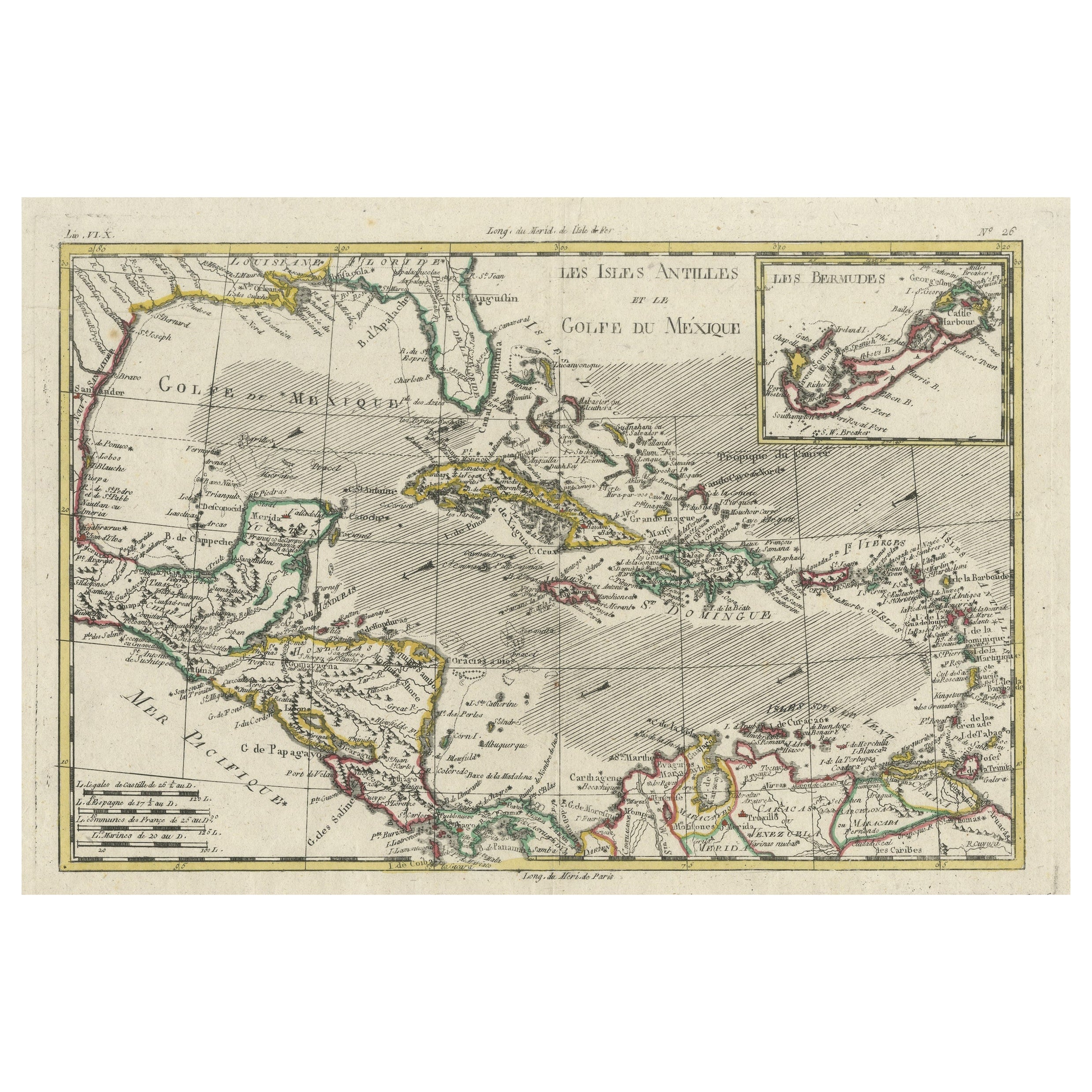
- Original Engraving of the West Indies, Gulf of Mexico, Antilles, Caribbean, 1780Located in Langweer, NLRigobert Bonne and G. Raynal's 1780 map of the West Indies, Gulf of Mexico, Antilles, and the Caribbean stands as a remarkable cartographic piece, offering a detailed and expansive v...Category
Antique Late 18th Century Maps
MaterialsPaper
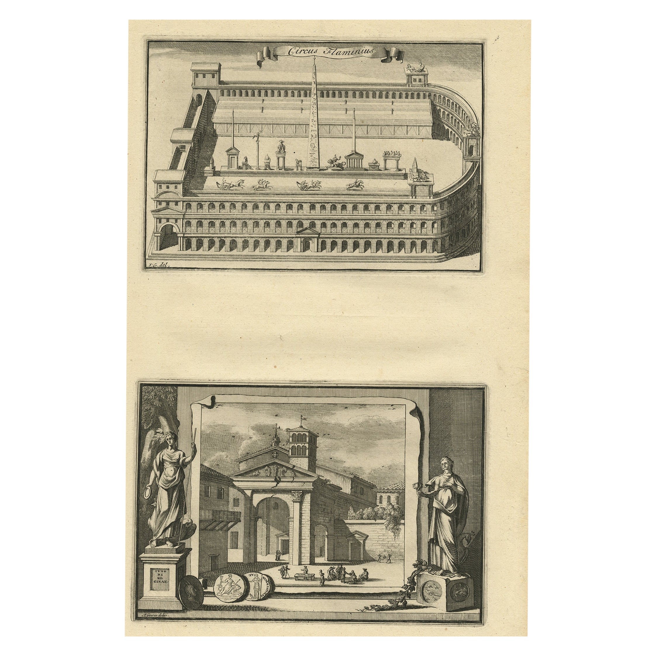
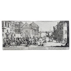
- Antique Engraving of Circus Flaminius, a Circular Area in Ancient Rome, 1704Located in Langweer, NLDescription: Antique print, titled: 'Circus Flaminius (…)' - This original old antique print shows a reconstruction of Circus Flaminius, a large, circular area in ancient Rome, l...Category
Antique Early 1700s Prints
MaterialsPaper
You May Also Like
- Antique Lithography Map, Isle of Wight, English, Framed, Engraving, CartographyLocated in Hele, Devon, GBThis is an antique lithography map of the Isle of Wight. An English, framed atlas engraving of cartographic interest, dating to the early 19th century and later. Superb lithography ...Category
Antique Early 19th Century British Regency Maps
MaterialsWood
- Jacques Callot "Misères Et Malheurs De La Guerre" Collection of Engraving 17thBy Jacques CallotLocated in Beuzevillette, FR“Les Misères Et Les Malheurs De La Guerre” (“The misfortunes of war”) more commonly called “the great miseries of war” (“The great miseries of war”) is a major work by the 17th centu...Category
Antique 17th Century French Louis XIII Prints
MaterialsPaper
- Map Colonies Francaises Martinique, 1845Located in BUNGAY, SUFFOLKColonies Francaises, Martinique, Amerique DU SUD Geographie et Statistique par V.Levasseur. Ing'r Geographe. Illustre par Raymond Bonheur, peintre. Grave par Laguihermie, Rue St...Category
Antique 19th Century French Maps
MaterialsPaper
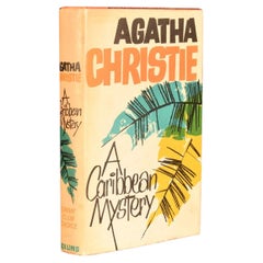
- 1964 A Caribbean MysteryBy Agatha ChristieLocated in Bath, GBAn exceptional signed first edition of this classic Miss Marple novel, signed from Christie to her secretary, Carlo Fisher. With a dedication from Christie to the front free endpape...Category
Vintage 1960s European Books
MaterialsPaper
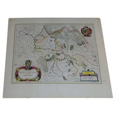
- 1656 "La Souverainete de Sedan et de Raucourt, et la Prevoste de Doncheri Ric004Located in Norton, MA1656 map entitled "La Souverainete de Sedan et de Raucourt, et la Prevoste de Doncheri," Hand Colored Ric0004. Description: Lovely map centered on Sedan and Doncheri an...Category
Antique 17th Century Dutch Maps
MaterialsPaper
- 19th Century Nautical Chart of MartiniqueLocated in Norwell, MAOriginal map of Martinique from 1887 with chartered waters around the island. Prepared from a French survey, completed in 1825, showing town, ports, rivers and tributaries. Published...Category
Antique 19th Century Nautical Objects


Recently Viewed
View AllMore Ways To Browse
Antique Copper Engravings
Collecting Antique Keys
Caribbean Wood
Caribbean Wood Furniture
Antique Copper Key
Hand Colored Copper Engraving
Fer Antique
Handcolored Engraving
Antique Copper Window
Window Card
Antique Steel Windows
Bay Window
Antique Bay Window
Used Furniture Anchorage
Antique Card Viewer
Antique Furniture Anchorage
Antique Pennsylvania Map
French School Map