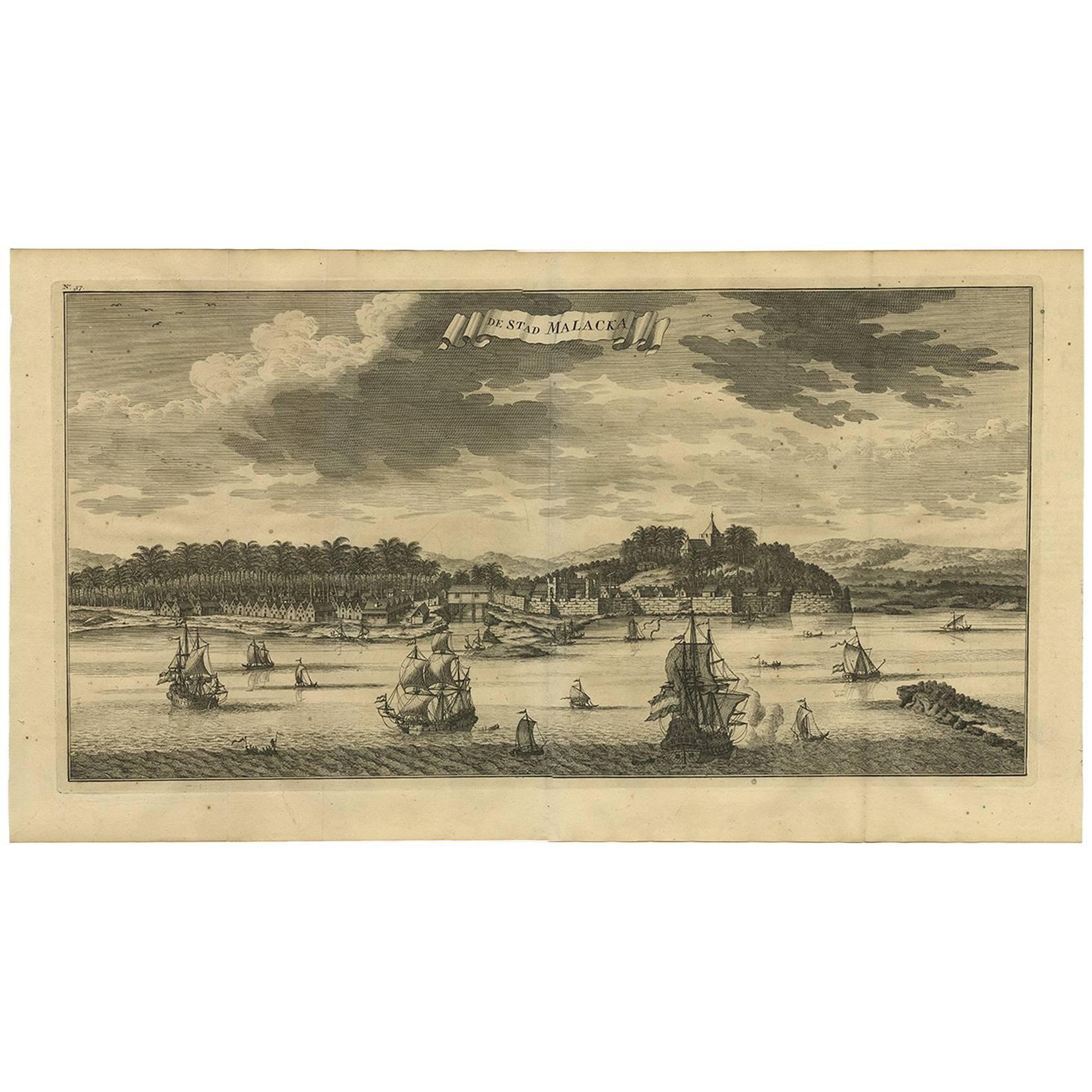
Items Similar to Detailed Original Antique Plan of the City and Fort of Malacca, Malaysia, 1764


Want more images or videos?
Request additional images or videos from the seller
1 of 5
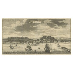
Detailed Original Antique Plan of the City and Fort of Malacca, Malaysia, 1764
About the Item
Description: Antique map titled 'Plan de la Ville et Forteresse de Malaca'. Detailed plan of the city and fort of Malacca on the southern Malay Peninsula, commanding the strategic straits of the same name.
Artists and Engravers: Made by 'Jakob van Schley' after 'Jacques Nicolas Bellin'. Jakob van der Schley (1715-1779) was a Dutch draughtsman and engraver, who studied under Bernard Picart. Jacques-Nicolas Bellin (1703-1772) was a French hydrographer, geographer and member of The Philosophes. His career, spanning over 50 years, caused an enormous outpt in maps, particular of maritime interest.
Condition: Fair, clipped and some wear. Please study image carefully.
- Dimensions:Height: 7.88 in (20 cm)Width: 5.91 in (15 cm)Depth: 0 in (0.02 mm)
- Materials and Techniques:
- Period:1760-1769
- Date of Manufacture:1764
- Condition:
- Seller Location:Langweer, NL
- Reference Number:
About the Seller
5.0
Platinum Seller
These expertly vetted sellers are 1stDibs' most experienced sellers and are rated highest by our customers.
Established in 2009
1stDibs seller since 2017
1,969 sales on 1stDibs
Typical response time: <1 hour
- ShippingRetrieving quote...Ships From: Langweer, Netherlands
- Return PolicyA return for this item may be initiated within 14 days of delivery.
More From This SellerView All
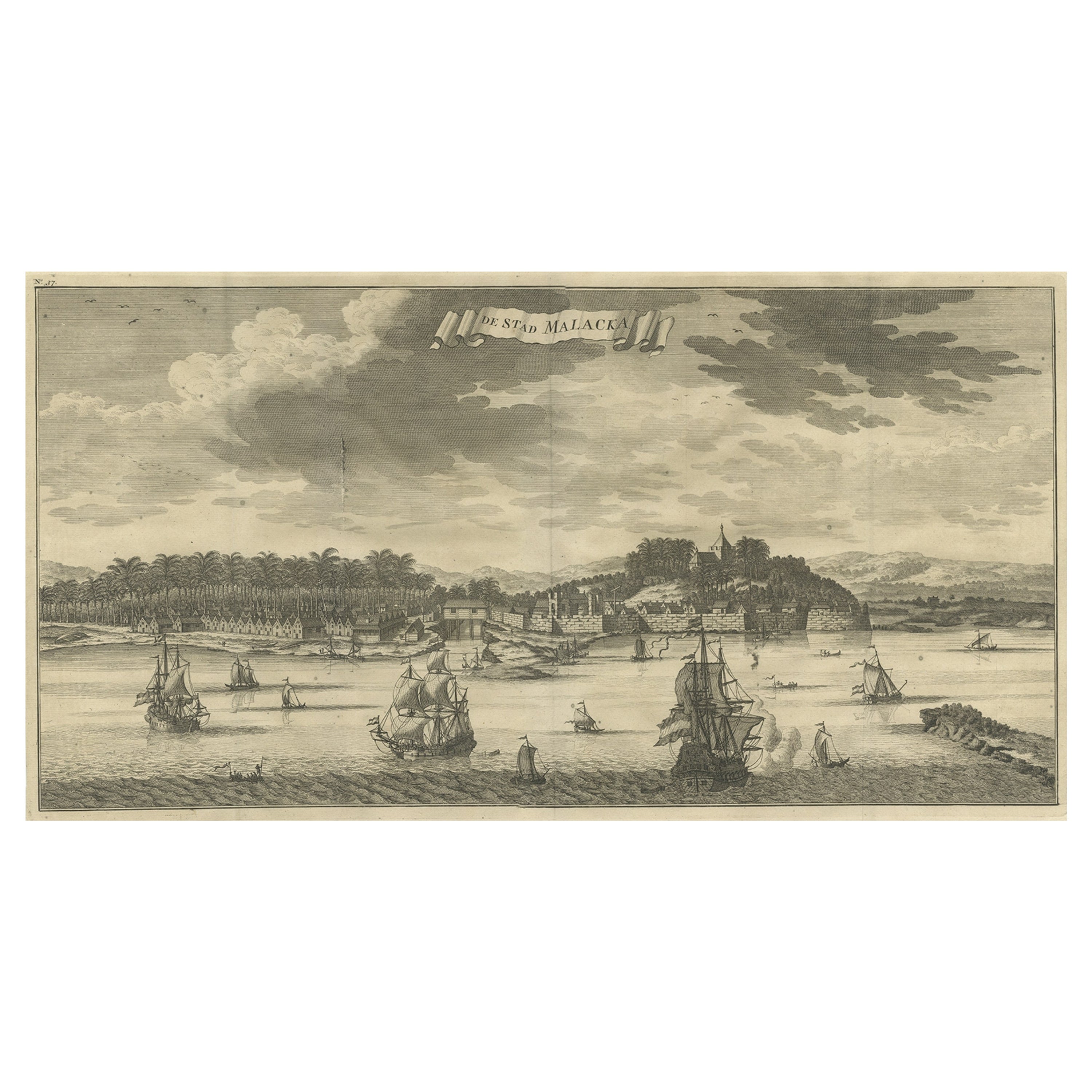
- Antique Panoramic View of the Town of Malacca, Malaysia, 1726Located in Langweer, NLAntique print Malaysia titled 'De Stad Malacka'. Decorative panoramic view of the town of Malacca with European vessels in the foreground. The old C...Category
Antique 1720s Maps
MaterialsPaper
- Antique Plan of the City of Bayonne, FranceLocated in Langweer, NLAntique map titled 'Plan de Bayonne'. Original old plan of the city of Bayonne, France. This map originates from 'Le Petit Atlas Maritime (..)' by J.N. Bellin. Published 1764. Be...Category
Antique Mid-18th Century Maps
MaterialsPaper
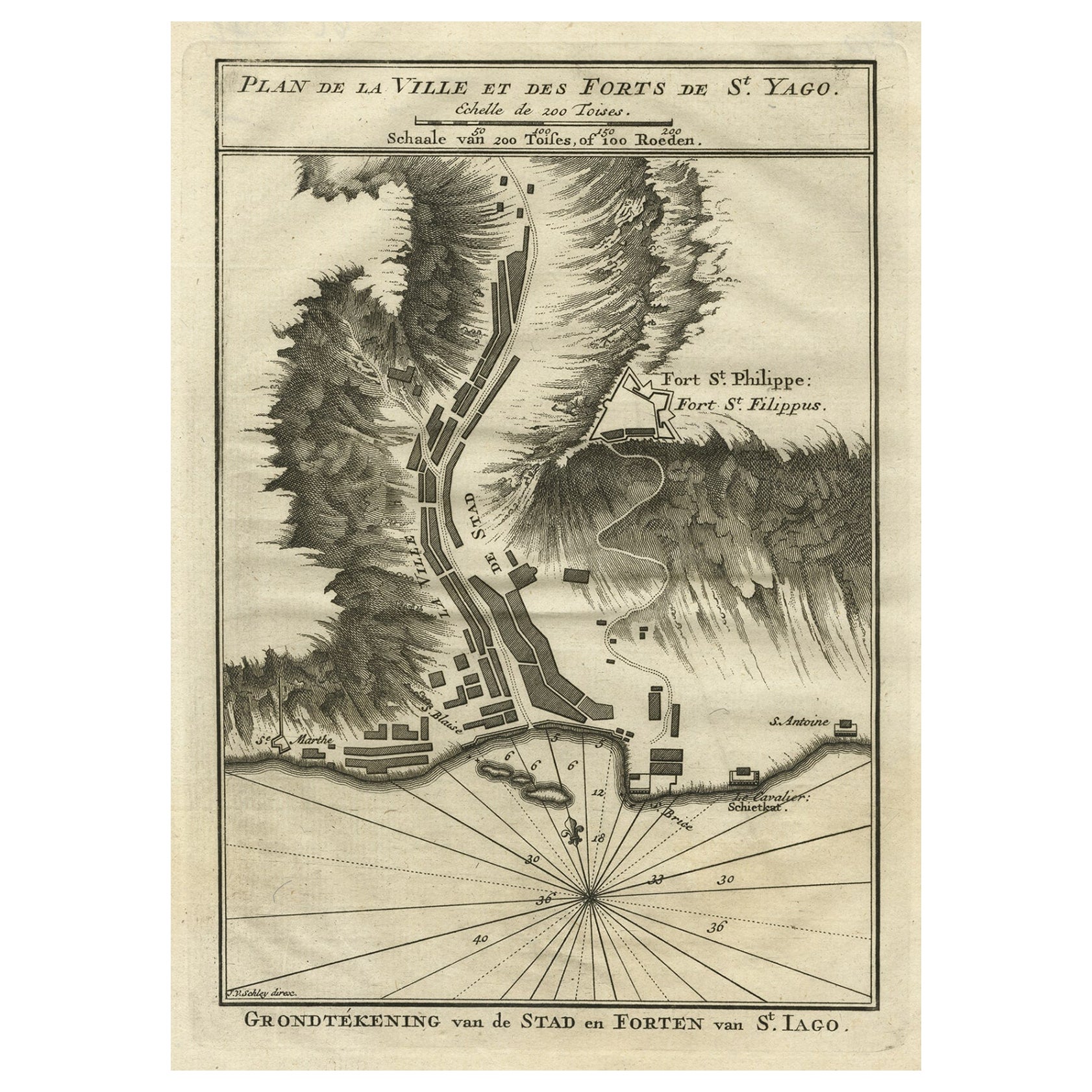
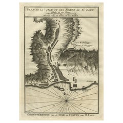
- Antique Plan of the Forts and Town of St. Yago in the Cape Verde Islands, 1747By Jakob van der SchleyLocated in Langweer, NLAntique map titled 'Plan de la Ville et des Forts de St. Yago - Grondtekening van de Stad en Forten van St. Iago'. Plan of the Forts and Town of St. Yago in the Cape Verde Islands. T...Category
Antique 18th Century Maps
MaterialsPaper
- Antique Print of the City of Malacca 'Malaysia' by F. Valentijn, circa 1730By F. ValentijnLocated in Langweer, NLThis copper-engraved view depicts the city of Malacca, with numerous ships sailing the Straits of Malacca. Valentyn was a prominent historian of the Dutch East India Company who is...Category
Antique Early 18th Century Prints
MaterialsPaper
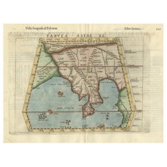
- Original Antique Ptolemaic Map of the Region of Thailand and MalaysiaLocated in Langweer, NLAntique map titled 'Tabula Asiae XI'. Based on the interpretations of Solinus and Munster, this Ptolemaic map covers the region roughly of Thailand and Malaysia. An oddly shaped (Mal...Category
Antique 16th Century Maps
MaterialsPaper
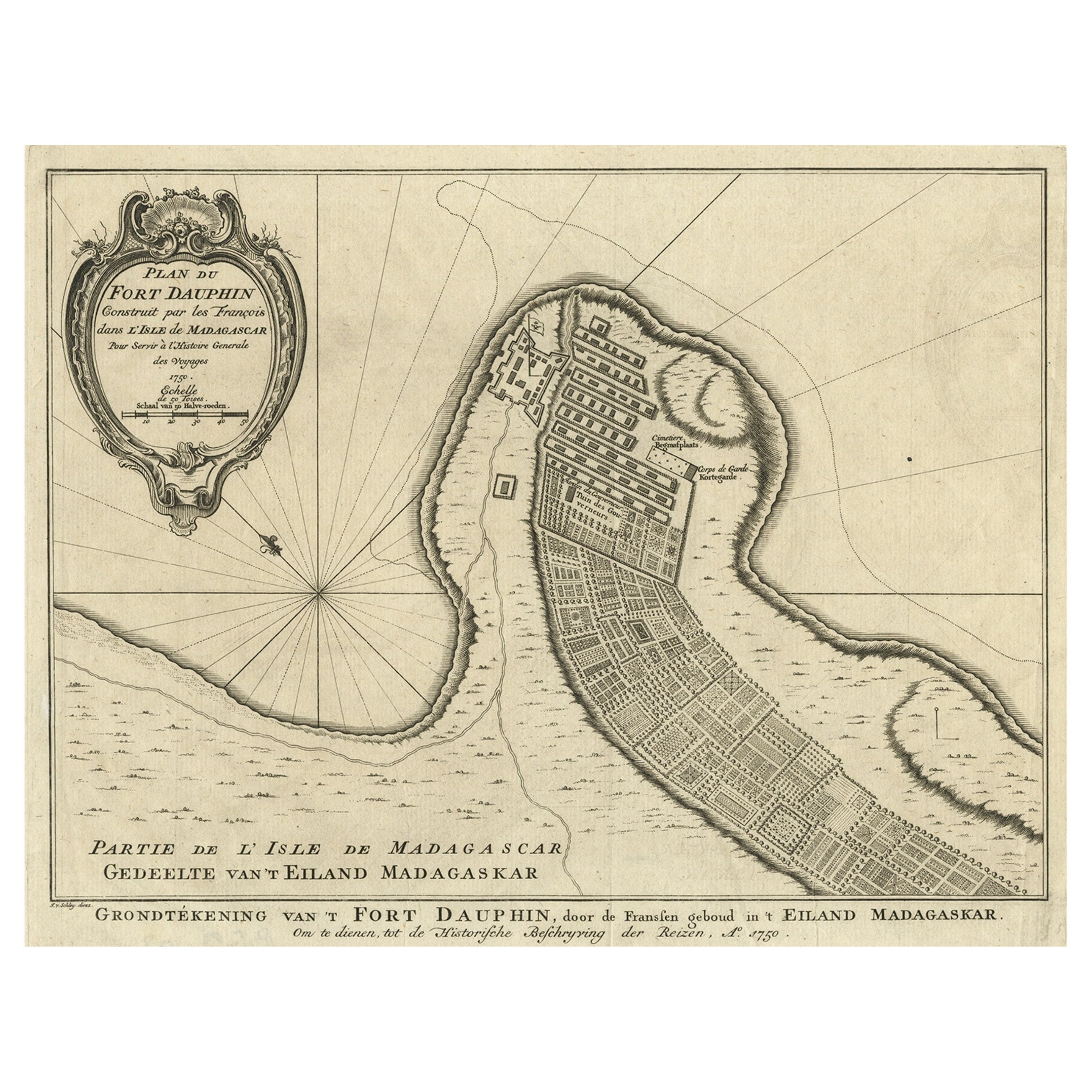
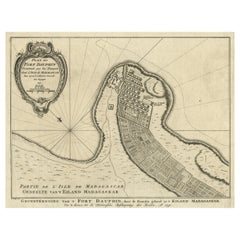
- Antique Plan of Fort Dauphin on Madagascar of the East Coast of Africa, 1756Located in Langweer, NLAntique map titled 'Plan du Fort Dauphin (..) - Grondtekening van 't Fort Dauphin'. Plan of Fort Dauphin on the island of Madagascar of the east coast of Africa. This print origi...Category
Antique 1750s Maps
MaterialsPaper


You May Also Like
- Original Antique Map / City Plan of Brussels by Tallis, circa 1850Located in St Annes, LancashireGreat map of Brussels. Steel engraving. Published by London Printing & Publishing Co. (Formerly Tallis), C.1850 Free shipping.Category
Antique 1850s English Maps
MaterialsPaper
- Catalogue of Engraved Views, Plans, Etc., Of New York City, 1st EdLocated in valatie, NYA catalogue of engraved views, plans, etc., Of New York City, (The Collection of Percy R. Pyne II). Privately Printed by The De Vinne Press, New York, 1912. Limited to 100 copies. Gr...Category
Early 20th Century American Books
MaterialsPaper
- Original Antique City Plan of Kansas City, USA. 1894By Rand McNally & Co.Located in St Annes, LancashireFabulous colorful map of Kansas City Original color By Rand, McNally & Co. Published, 1894 Unframed Slightly reduced bottom margin. Free shipping.Category
Antique 1890s American Maps
MaterialsPaper

- Dutch Map and City Plan of La Roche-sur-Foron, France, 17th Century Hand ColoredBy Coenraet DeckerLocated in Alamo, CA"Rupes Allobrogum vulgo La Roche" by Dutch engraver Coenraet Decker (1650-1685) is from the atlas Theatrum Statuum Regiae Celestudinis Sabaudiae Ducis, published in 1682. This richly...Category
Antique Late 17th Century Dutch Maps
MaterialsPaper
- Original Antique City Plan of Milwaukee, USA, 1894By Rand McNally & Co.Located in St Annes, LancashireFabulous colorful map of Milwaukee Original color By Rand, McNally & Co. Published, 1894 Unframed Free shipping.Category
Antique 1890s American Maps
MaterialsPaper
- Original Antique Map of The World by Thomas Clerk, 1817Located in St Annes, LancashireGreat map of The Eastern and Western Hemispheres On 2 sheets Copper-plate engraving Drawn and engraved by Thomas Clerk, Edinburgh. Published by Mackenzie And Dent, 1817 ...Category
Antique 1810s English Maps
MaterialsPaper


Recently Viewed
View AllMore Ways To Browse
Dutch Maritime
Antique Malaysia
Malaysian Antique
Antique Furniture Malaysia
Malaysian Antique Furniture
Malaysian Map
Antique Paper Clips
Antique Paper Clip
Malaysia Map
Dutch Malacca
18th Century Map London
Antique Quadrant
Coastal Maps
Antique Maps Australia
Antique Maps Of Australia
Map Of Belgium
Dutch Coat Of Arms
Agriculture Map