Items Similar to Antique Map of the Region of Wonseradeel by Schotanus, 1664

Want more images or videos?
Request additional images or videos from the seller
1 of 5
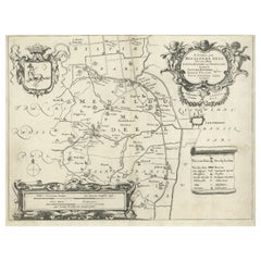
Antique Map of the Region of Wonseradeel by Schotanus, 1664
About the Item
Antique map titled 'De Grietenije van Wonsera-deel (..).' Map of the Grietenij of Wonseradeel, Friesland, The Netherlands. Multiple cartouches, key and coat of arms. "Beschrijvinge ende nieuwe caerten van de Heerlyckheydt van Frieslandt (…).", by Schotanus a Sterringa, first published in 1664.
Artists and Engravers: Bernardus Schotanus a Sterringa (1640-1704) was a Dutch / Frisian cartographer from Franeker.
Condition: Fair, large repair on folding line and bottom corners. Shows toning and wear. Blank verso. Please study image carefully.
Date: 1664
Overall size: 36.5 x 30 cm.
Image size: 36.5 x 27.5 cm.
We sell original antique maps to collectors, historians, educators and interior decorators all over the world. Our collection includes a wide range of authentic antique maps from the 16th to the 20th centuries. Buying and collecting antique maps is a tradition that goes back hundreds of years. Antique maps have proved a richly rewarding investment over the past decade, thanks to a growing appreciation of their unique historical appeal. Today the decorative qualities of antique maps are widely recognized by interior designers who appreciate their beauty and design flexibility. Depending on the individual map, presentation, and context, a rare or antique map can be modern, traditional, abstract, figurative, serious or whimsical. We offer a wide range of authentic antique maps for any budget.
- Creator:B. Schotanus (Artist)
- Dimensions:Height: 11.82 in (30 cm)Width: 14.38 in (36.5 cm)Depth: 0 in (0.01 mm)
- Materials and Techniques:
- Period:
- Date of Manufacture:1664
- Condition:Repaired: Large repair on folding line and bottom corners. Rewoven. Condition: Fair, large repair on folding line and bottom corners. Shows toning and wear. Blank verso. Please study image carefully.
- Seller Location:Langweer, NL
- Reference Number:
About the Seller
5.0
Platinum Seller
These expertly vetted sellers are 1stDibs' most experienced sellers and are rated highest by our customers.
Established in 2009
1stDibs seller since 2017
1,970 sales on 1stDibs
Typical response time: <1 hour
- ShippingRetrieving quote...Ships From: Langweer, Netherlands
- Return PolicyA return for this item may be initiated within 14 days of delivery.
More From This SellerView All
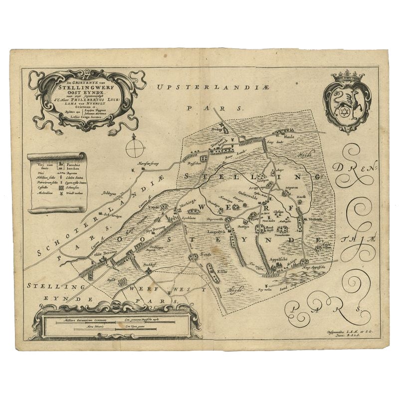
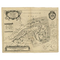
- Antique Map of the Region of Ooststellingwerf by Schotanus, 1664By B. SchotanusLocated in Langweer, NLAntique map titled 'De Grietenije van Stellingwerf oost eynde (..).' Map of the Grietenij of Ooststellingwerf, Friesland, The Netherlands. Multiple cartouches, key and coat of arms. ...Category
Antique 17th Century Maps
MaterialsPaper
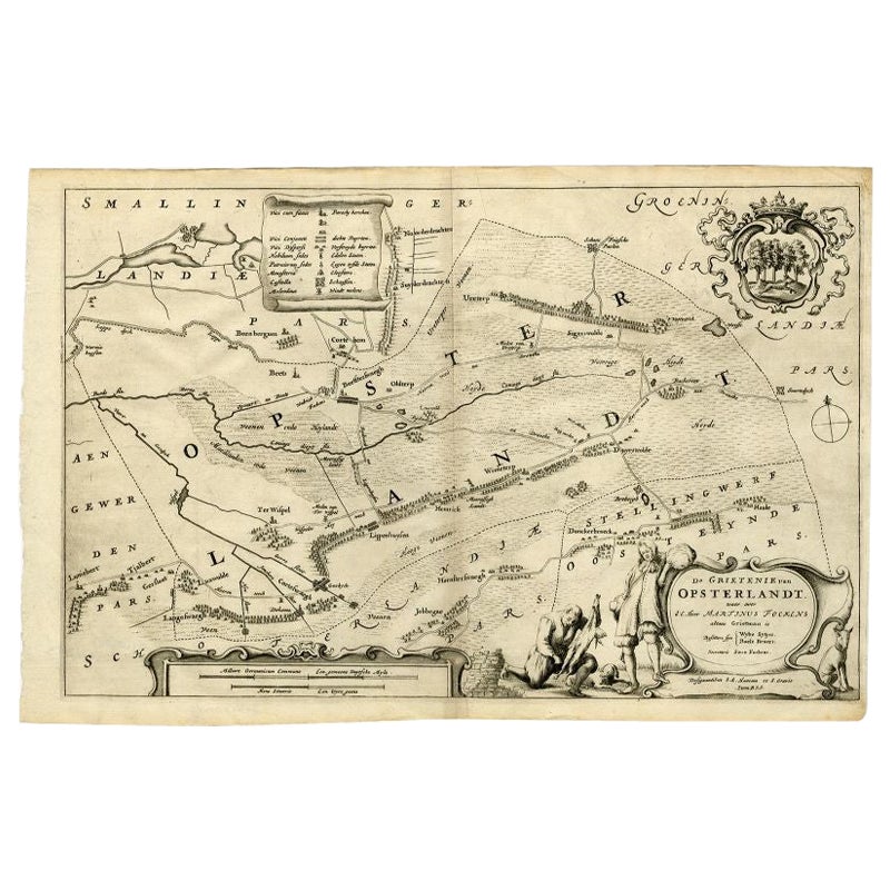
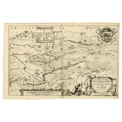
- Antique Map of the Region of Opsterland by Schotanus, 1664By B. SchotanusLocated in Langweer, NLAntique map titled 'De Grietenie van Opsterlandt : waer over d'e. heer Martinus Fockens altans grietman is, bysitters syn Wybe Sytjes, Boele Broers, secretaris Saco Fockens.' Detaile...Category
Antique 17th Century Maps
MaterialsPaper
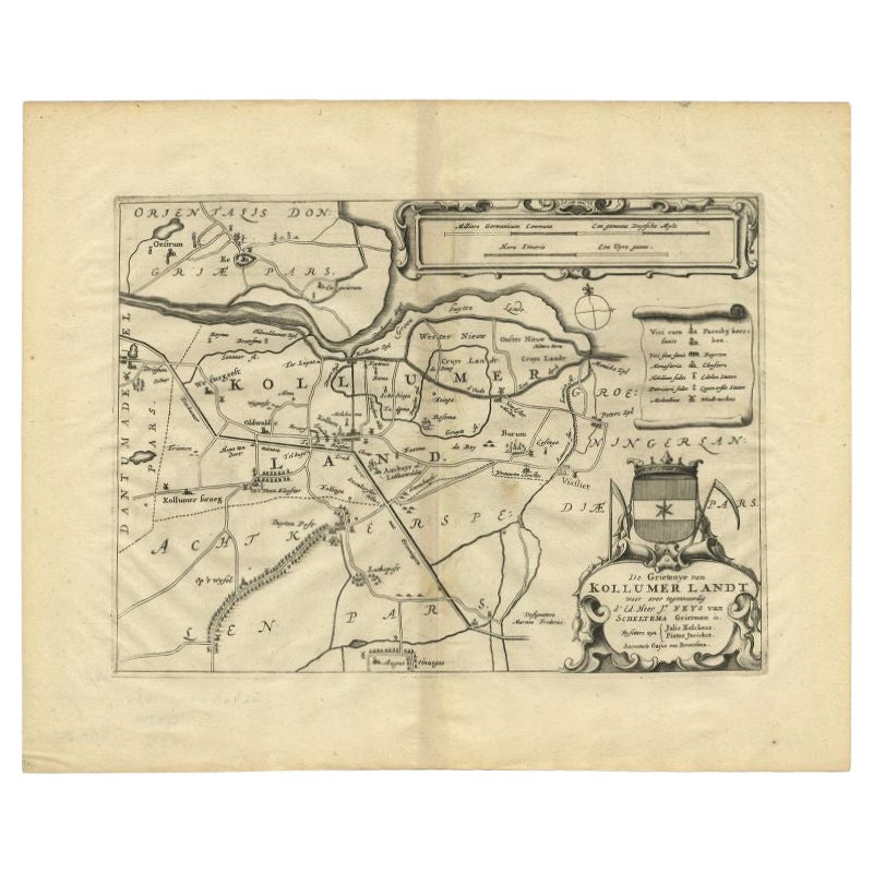
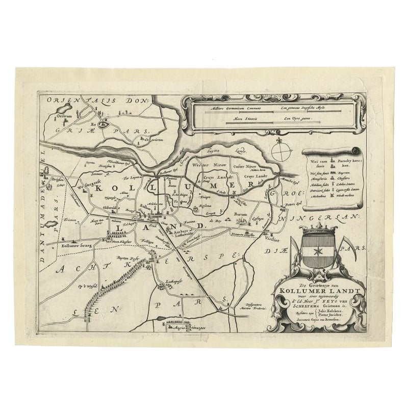
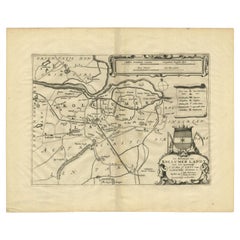
- Antique Map of the Region of Kollumerland by Schotanus, 1664By B. SchotanusLocated in Langweer, NLAntique map titled 'De Grietenije van Kollumer Landt (..).' Map of the Grietenij of Kollumerland, Friesland, The Netherlands. Multiple cartouches, key and coat of arms. "Beschrijving...Category
Antique 17th Century Maps
MaterialsPaper
- Antique Map of the Region of Menaldumadeel by Schotanus, 1664By B. SchotanusLocated in Langweer, NLAntique map titled 'De Grietenie van Menaldema Deel (..)'. Very decorative regional map of the Grietenij of Menaldumadeel, west of Leeuwarden, Friesland, The Netherlands. Multiple ca...Category
Antique 17th Century Maps
MaterialsPaper
- Antique Map of the Region of Kollumerland by Schotanus, 1664By B. SchotanusLocated in Langweer, NLAntique map titled 'De Grietenije van Kollumer landt (..).' Map of the Grietenij of Kollumerland, Friesland, The Netherlands. Multiple cartouches, key and coat of arms. "Beschrijving...Category
Antique 17th Century Maps
MaterialsPaper
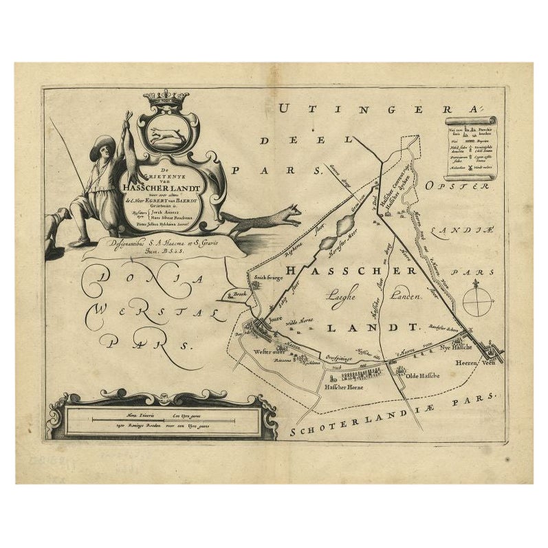
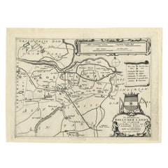
- Antique Map of the Region of Haskerland by Schotanus, 1664By B. SchotanusLocated in Langweer, NLAntique map titled 'De Grietenije van Hasscher Landt (..)'. Map of the Grietenij of Haskerland, Friesland, The Netherlands. Multiple cartouches, key and coat of arms. Originates from...Category
Antique 17th Century Maps
MaterialsPaper
You May Also Like
- 1861 Topographical Map of the District of Columbia, by Boschke, Antique MapLocated in Colorado Springs, COPresented is an original map of Albert Boschke's extremely sought-after "Topographical Map of the District of Columbia Surveyed in the Years 1856 ...Category
Antique 1860s American Historical Memorabilia
MaterialsPaper
- 1594 Maurice Bouguereau Map of the Region Limoges, France, Ric0015Located in Norton, MA1594 Maurice Bouguereau map of the region Limoges, France, entitled "Totivs Lemovici et Confinium Pro Uinciarum Quantum ad Dioecefin Lemo Uicenfen Fpectant," Hand Colored Ric0015 Jean IV Le Clerc...Category
Antique 16th Century Dutch Maps
MaterialsPaper
- The Normandy Region of France: A 17th C. Hand-colored Map by Sanson and JaillotBy Nicolas SansonLocated in Alamo, CAThis large hand-colored map entitled "Le Duché et Gouvernement de Normandie divisée en Haute et Basse Normandie en divers Pays; et par evêchez, avec le Gouvernement General du Havre ...Category
Antique 1690s French Maps
MaterialsPaper
- 17th Century Hand Colored Map of the Liege Region in Belgium by VisscherBy Nicolaes Visscher IILocated in Alamo, CAAn original 17th century map entitled "Leodiensis Episcopatus in omnes Subjacentes Provincias distincté divisusVisscher, Leodiensis Episcopatus" by Nicolaes Visscher II, published in Amsterdam in 1688. The map is centered on Liege, Belgium, includes the area between Antwerp, Turnhout, Roermond, Cologne, Trier and Dinant. This attractive map is presented in a cream-colored mat measuring 30" wide x 27.5" high. There is a central fold, as issued. There is minimal spotting in the upper margin and a tiny spot in the right lower margin, which are under the mat. The map is otherwise in excellent condition. The Visscher family were one of the great cartographic families of the 17th century. Begun by Claes Jansz Visscher...Category
Antique Late 17th Century Dutch Maps
MaterialsPaper
- Original Antique Map of The World by Thomas Clerk, 1817Located in St Annes, LancashireGreat map of The Eastern and Western Hemispheres On 2 sheets Copper-plate engraving Drawn and engraved by Thomas Clerk, Edinburgh. Published by Mackenzie And Dent, 1817 ...Category
Antique 1810s English Maps
MaterialsPaper
- 17th Century Hand-Colored Map of a Region in West Germany by JanssoniusBy Johannes JanssoniusLocated in Alamo, CAThis attractive highly detailed 17th century original hand-colored map is entitled "Archiepiscopatus Maghdeburgensis et Anhaltinus Ducatus cum terris adjacentibus". It was published ...Category
Antique Mid-17th Century Dutch Maps
MaterialsPaper


Recently Viewed
View AllMore Ways To Browse
Map Of Roman Empire
Map Of Virginia
Roman Empire Map
Antique Furniture Western Australia
Caribbean Map
Greek Asia Minor
Indian Ocean Antique Map
Map Of Caribbean
Thailand Map
African Money
Antique Hurst
Antique Map Poland
King Charles I Of England
Map Railroad
42 North Antiques
Antique German Compass
Antique Map Box
Antique Map Of Poland