Items Similar to Map of The Italian Peninsula with the islands of Sicily, Sardinia, Corsica, 1880


Want more images or videos?
Request additional images or videos from the seller
1 of 6
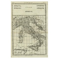
Map of The Italian Peninsula with the islands of Sicily, Sardinia, Corsica, 1880
About the Item
This map, titled "ITALIA, Sicilia, Sardinia, Corsica," represents the Italian Peninsula along with the islands of Sicily, Sardinia, and Corsica. Inset maps offer detailed views of "Roma" with an elaborate depiction of the ancient Roman Forum, signifying its significance as a center of political, religious, and social life in the Roman Republic and Empire.
From the "Spruner-Menke Atlas Antiquus," this map is a work by Karl Spruner von Merz, later revised by Theodorus Menke. Known for meticulous historical cartography, the atlas served as an academic resource, depicting various regions through different historical eras.
The period depicted might be during the Roman Republic or early Empire, indicated by the prominent display of the Roman Forum in the inset, which was the core of Roman public life during these times.
The map is interesting for several reasons:
1. **Historical Insight**: It provides a visualization of Italy's ancient regional divisions, roads, and cities.
2. **Cultural Heritage**: The detailed inset of Rome's Forum is a snapshot of one of history's most influential urban centers.
3. **Topographical Detail**: The map shows the topography of Italy, including the Apennine mountain range, the Po Valley, and the volcanic areas, critical to Italy's ancient and modern history.
4. **Island Representation**: The inclusion of the major islands underscores their historical importance in the Mediterranean context.
5. **Navigation and Trade**: The map may detail ancient trade routes and ports, reflecting the maritime prowess of ancient Rome.
6. **Military Campaigns**: It likely includes sites of major battles and military campaigns, which were instrumental in Rome's expansion.
This map would be particularly useful for those interested in the geographical aspects of ancient Rome, the development of its provinces, and the broader historical context of the Mediterranean region during antiquity.
- Dimensions:Height: 15.56 in (39.5 cm)Width: 18.51 in (47 cm)Depth: 0 in (0.02 mm)
- Materials and Techniques:
- Period:
- Date of Manufacture:1880
- Condition:Good, given age. General age-related toning, especially around the edges. The vertical folding line as issued. Please study scan carefully.
- Seller Location:Langweer, NL
- Reference Number:
About the Seller
5.0
Platinum Seller
These expertly vetted sellers are 1stDibs' most experienced sellers and are rated highest by our customers.
Established in 2009
1stDibs seller since 2017
1,967 sales on 1stDibs
Typical response time: <1 hour
- ShippingRetrieving quote...Ships From: Langweer, Netherlands
- Return PolicyA return for this item may be initiated within 14 days of delivery.
More From This SellerView All
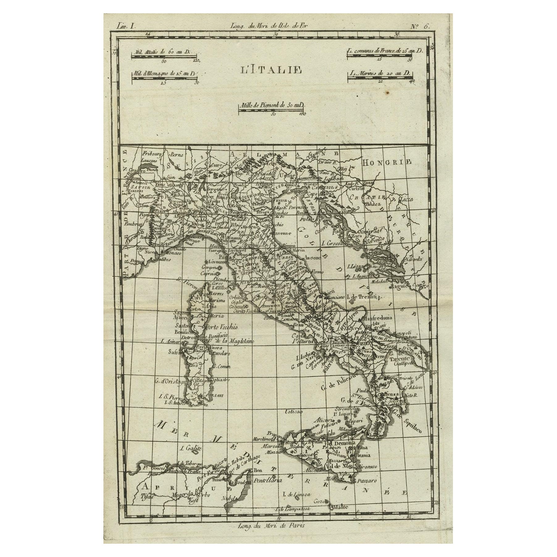
- Antique Map of Italy, Corsica, Sardinia and Sicily, ca.1780Located in Langweer, NLDescription: Antique map titled 'L'Italie.' Map of Italy, Corsica, Sardinia and Sicily. Highly detailed, showing towns, rivers, some topographical features and political boundari...Category
Antique 1780s Maps
MaterialsPaper
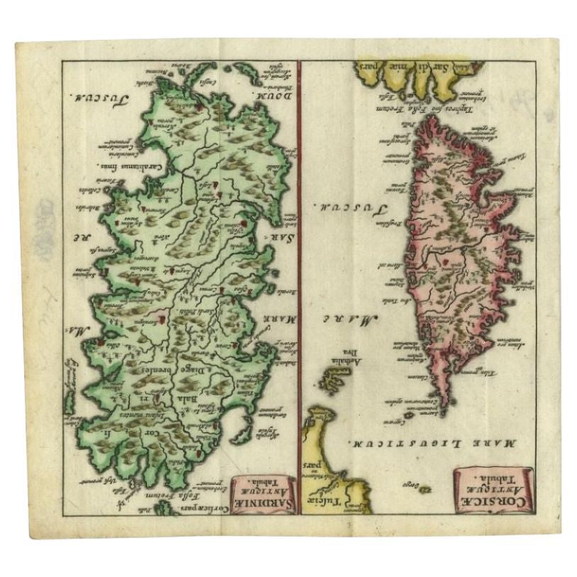
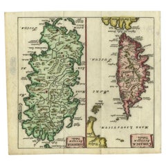
- Antique Map of the Islands of Corsica and Sardinia, 1685Located in Langweer, NLAntique map titled 'Corsicae Antiquae Tabula - Sardiniae Antiquae Tabula.' Two charming miniature maps on one sheet, showing the islands Corsica and Sardinia from the pocket atlas 'I...Category
Antique 17th Century Maps
MaterialsPaper
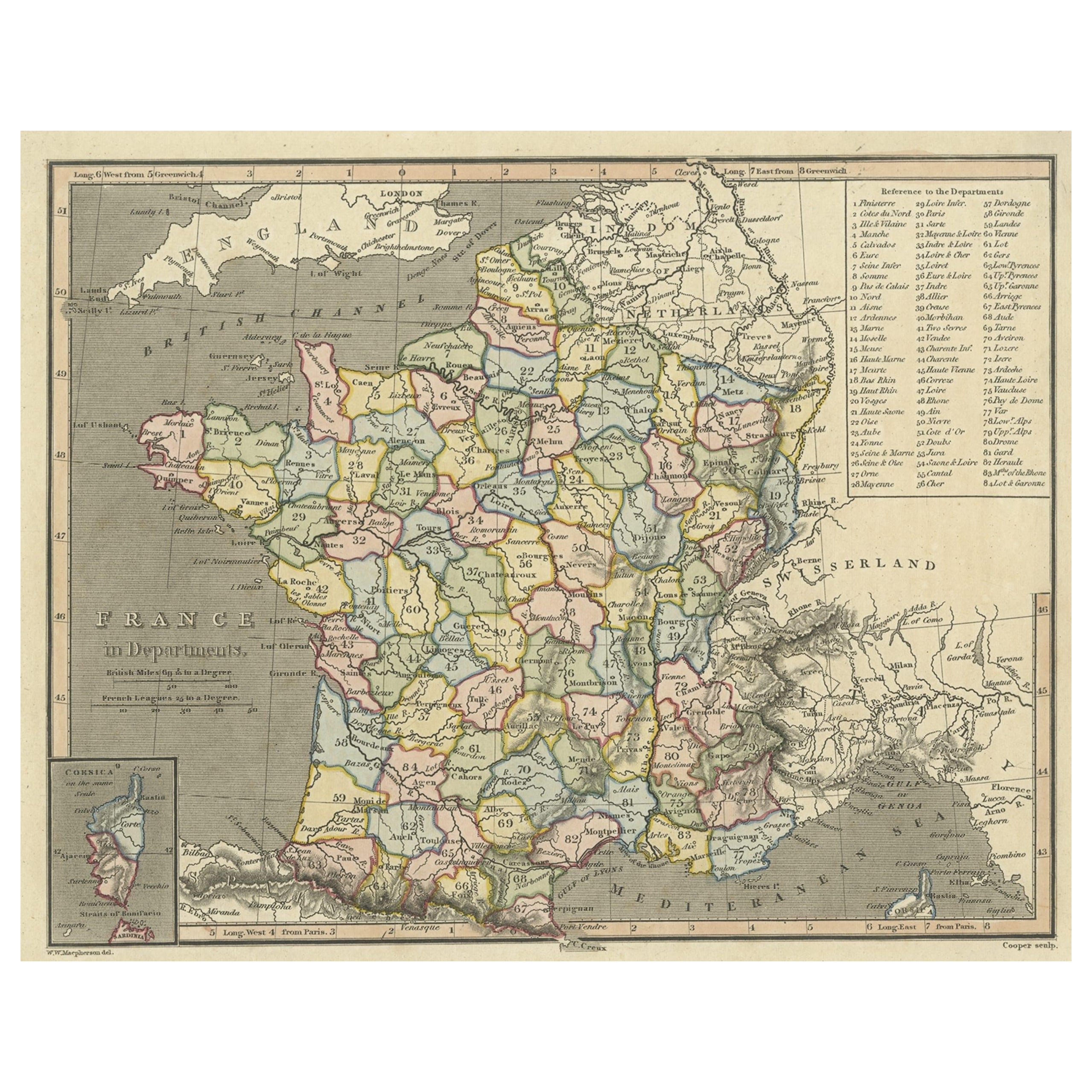
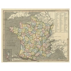
- Antique Map of France with Inset Map of the Island of Corsica, 1820Located in Langweer, NLAntique map titled 'France in Departments'. Old map of France, with small inset map of the island of Corsica. Includes a table with reference to the departments. Artists and Engr...Category
Antique 19th Century Maps
MaterialsPaper
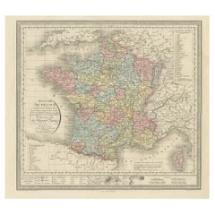
- Antique Map of France with an Inset Map of the Island of Corsica, c.1820Located in Langweer, NLAntique map titled 'Frankrijk naar de nieuwste bepalingen meerendeels gevolgd naar Lapie'. Beautiful map of France with an inset map of the island of Corsica. Includes a table with r...Category
Antique 19th Century Maps
MaterialsPaper
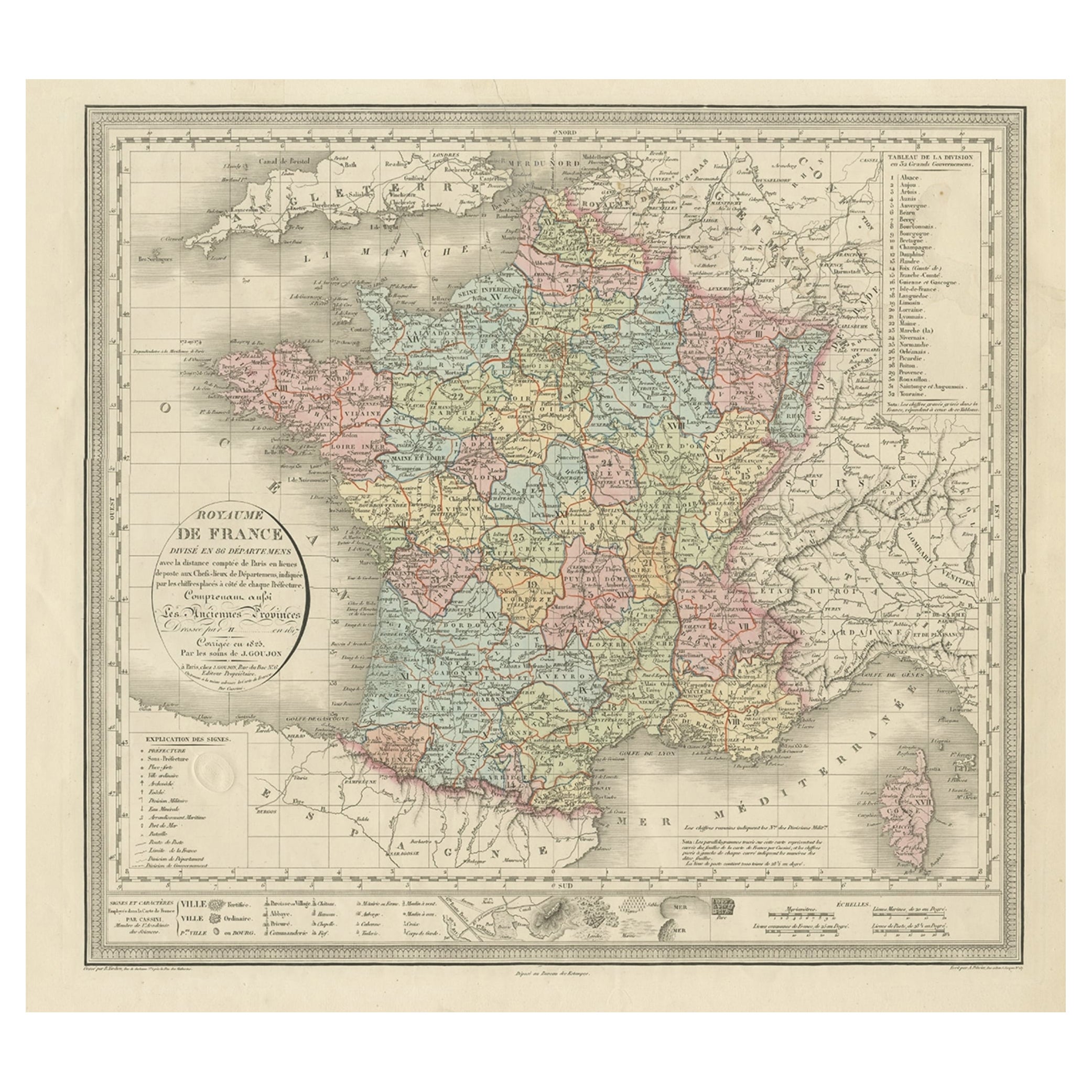
- Antique Map of France and the Island of Corsica, c.1825Located in Langweer, NLAntique map titled 'Royaume de France divisé en 86 Départemens'. Old map of France, revised in 1825. Also shows the Island of Corsica. Source unknown, to be determined. Artists and E...Category
Antique 19th Century Maps
MaterialsPaper
- Antique Map of Italy, Showing Corsica, Sardinia, Croatia, Malta and More, C.1740Located in Langweer, NLAntique map titled 'Nieuwe Kaart van Italie na de Nieuwste waarnemingen van de l'Isle en andere.' Attractive detailed map showing Italy as well as Corsica, Sardinia, Minorca, Croat...Category
Antique 18th Century Maps
MaterialsPaper


You May Also Like
- Italy, Sicily, Sardinia, Corsica and Dalmatian Coast: A 17th Century Dutch MapBy Theodorus DanckertsLocated in Alamo, CAThis hand colored 17th century Dutch map entitled "Novissima et Accuratissima totius Italiae Corsicae et Sardiniae Descriptio" by Theodore Danckerts depicts the Italian Peninsula in ...Category
Antique Late 17th Century Dutch Maps
MaterialsPaper
- Old Nautical Map of CorsicaLocated in Alessandria, PiemonteST/556/1 - Old map of Corsica isle, surveyed by Captain Hell, of the French Royal Navy in 1824, engraved and published on 1874, with additions and corre...Category
Antique Early 19th Century English Other Prints
MaterialsPaper
- Map of the Kingdom of Sardinia and Part of the Kingdom of Genoa, RomeBy Giovanni Maria CassiniLocated in Hamilton, Ontario18th century map by Italian engraver Giovanni Maria Cassini (Italy 1745-1824). Map of Part of the Kingdom of Sardinia and Part of the Kingdom of Genoa: Rome. This is a hand colored a...Category
Antique 18th Century Italian Maps
MaterialsPaper
- 1880s Map of The Italian Alps from Milan to Lake GardaLocated in Roma, ITGeographical Map of the Profile and Elevation of the Italian Alps from Milano to Lake Garda. The map features the name of each peak and key cities including Monza, Brescia and Bergam...Category
Antique 1880s Italian Maps
MaterialsParchment Paper
- Large Original Vintage Map of The Pacific Islands Including HawaiiLocated in St Annes, LancashireGreat map of The Pacific Islands Unframed Original color By John Bartholomew and Co. Edinburgh Geographical Institute Published, circa 1...Category
Vintage 1920s British Maps
MaterialsPaper
- 1868 Map of the Upper Part of the Island of Manhattan Above 86th StreetBy Wm. Rogers Mfg. Co.Located in San Francisco, CAThis wonderful piece of New York City history is over 150 years old. It depicts 86th street and above. It was lithographed by WC Rogers and company. It was made to show what was the Battle of Harlem during the Revolutionary war...Category
Antique 1860s American American Colonial Maps
MaterialsPaper


Recently Viewed
View AllMore Ways To Browse
Antique Center Islands
Rome Maps
Italian Military
Campaign Display
Antique Forum
Karl May
Antique Furniture Forum
Political Campaign
Heritage Campaign
Antique Po
Constantinople Map
Map Colonial Africa
Map Of Constantinople
Pair Of Antique Maps
Romania Map
Antique Chicago Maps
Antique Furniture Alabama
Antique Furniture Dundee