Items Similar to Map of the Hawaiian Islands with a Large Inset of Karakakooa Bay, 1803


Want more images or videos?
Request additional images or videos from the seller
1 of 6
Map of the Hawaiian Islands with a Large Inset of Karakakooa Bay, 1803
About the Item
Antique map titled 'Kaart van de Sandwich Eilanden'.
Map of the Hawaiian Islands with a large inset of Karakakooa Bay, including soundings and anchorages. Originates from 'Reizen Rondom de Waereld door James Cook (..)'.
Artists and Engravers: Translated by J.D. Pasteur. Published by Honkoop, Allart en Van Cleef.
- Dimensions:Height: 11.82 in (30 cm)Width: 19.1 in (48.5 cm)Depth: 0 in (0.02 mm)
- Materials and Techniques:
- Period:
- Date of Manufacture:1803
- Condition:Wear consistent with age and use. Condition: Very good, general age-related toning and minor foxing. Please study image carefully.
- Seller Location:Langweer, NL
- Reference Number:
About the Seller
5.0
Platinum Seller
These expertly vetted sellers are 1stDibs' most experienced sellers and are rated highest by our customers.
Established in 2009
1stDibs seller since 2017
1,965 sales on 1stDibs
Typical response time: <1 hour
- ShippingRetrieving quote...Ships From: Langweer, Netherlands
- Return PolicyA return for this item may be initiated within 14 days of delivery.
More From This SellerView All
- Antique Map of the Island of Tahiti, Polynesia, 1803Located in Langweer, NLAntique map Tahiti titled 'Kaart van het Eiland Otahiti'. Antique map of the Island of Tahiti, Polynesia. Originates from 'Reizen Rondom de Waereld door James Cook (..)'. Art...Category
Antique Early 1800s Maps
MaterialsPaper
- Antique Map of Scotland With an Inset Map of the Shetland Islands, 1854Located in Langweer, NLStunning Map of Scotland that will look beautiful in any setting framed on the wall. Description: Large Antique map titled 'Scotland with its Islands, drawn from the Topographical surveys...Category
Antique 1850s Maps
MaterialsPaper
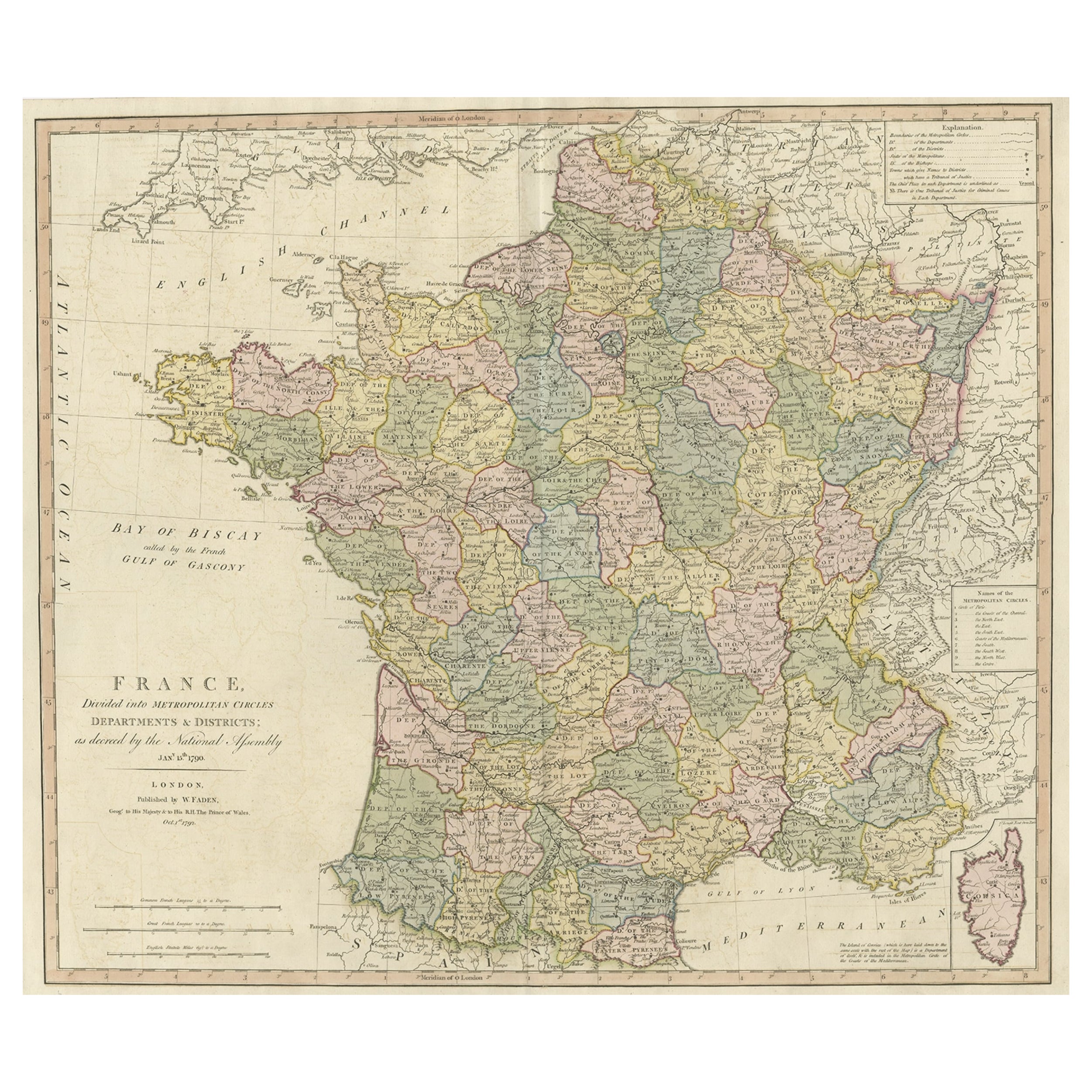
- Large Antique Map of France, with a Small Inset of the Island of Corsica, 1792Located in Langweer, NLAntique map titled 'France divided into Metropolitan Circles (..)'. Large, original antique map of France, with a small inset of the island of Corsica. Published by W. Faden, 179...Category
Antique 1790s Maps
MaterialsPaper
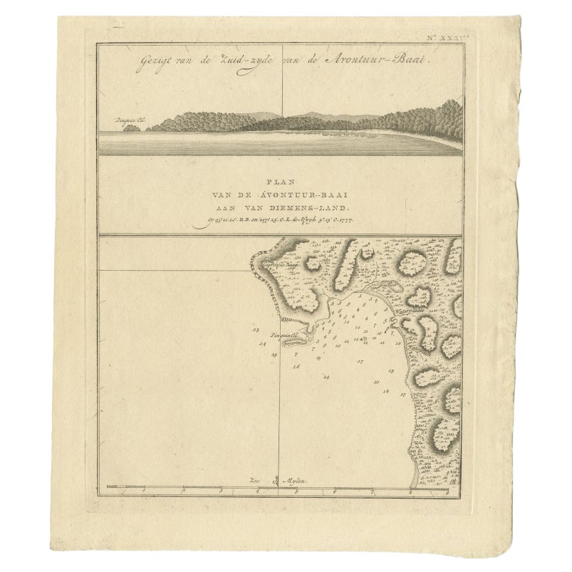
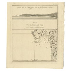
- Antique Map of Adventure Bay, Van Diemens Land, Nowadays Tasmania Island, 1803Located in Langweer, NLAntique map Adventure Bay titled 'Plan van de Avontuur-Baai aan van Diemens-Land'. Antique map and coastal view of Adventure Bay. Originates from 'Reizen Ro...Category
Antique 19th Century Maps
MaterialsPaper
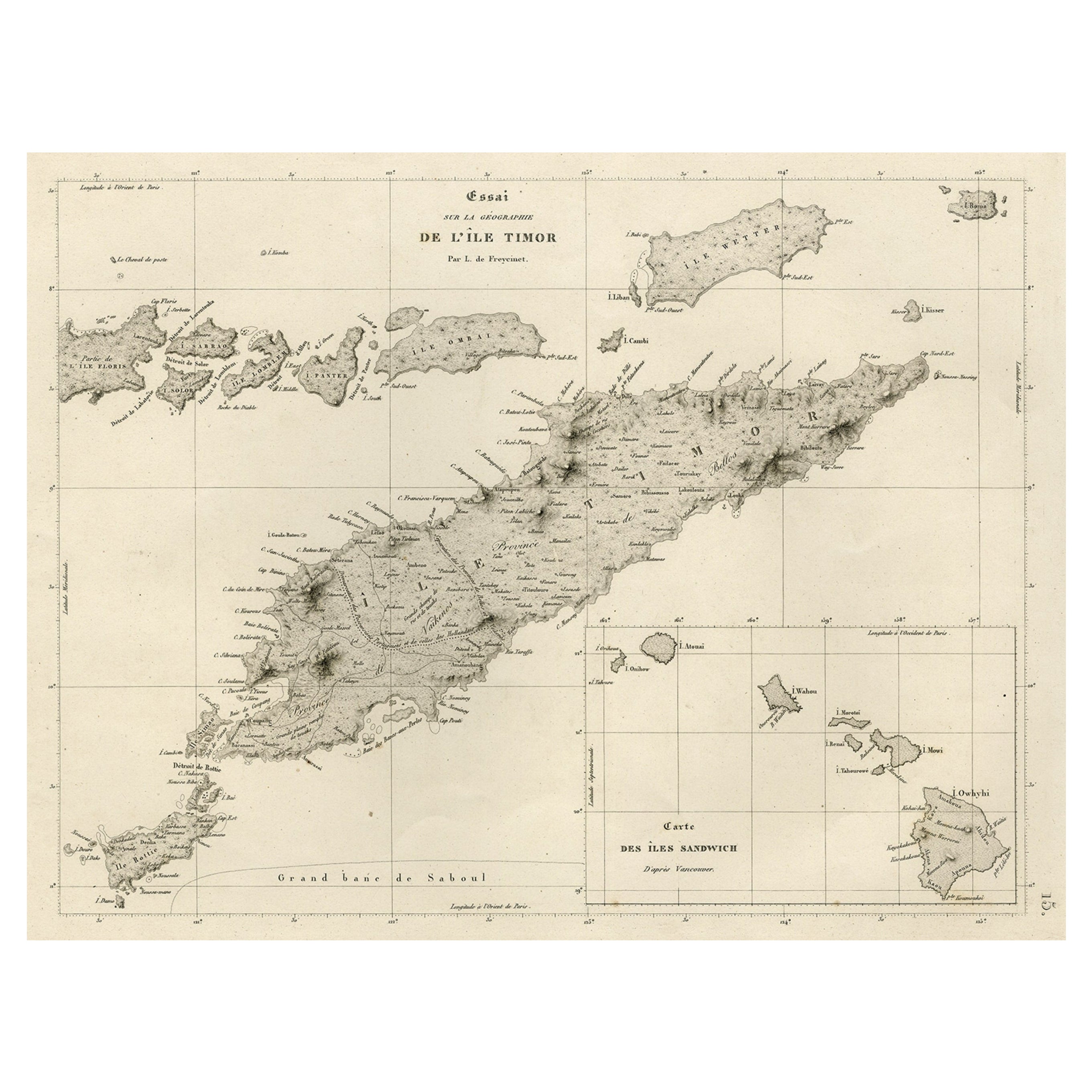
- Rare Antique Map with Timor and Nearby Islands Plus an Inset of Hawaii, 1825Located in Langweer, NLAntique map titled 'Essai sur la Geographie de l'Ile Timor.' A map showing Timor and the surrounding nearby islands (Floris, Sabrao, Solor, Lomblem, Panter, Ombai and Wetter. Wit...Category
Antique 1820s Maps
MaterialsPaper
- Antique Map of France with an Inset Map of the Island of Corsica, c.1820Located in Langweer, NLAntique map titled 'Frankrijk naar de nieuwste bepalingen meerendeels gevolgd naar Lapie'. Beautiful map of France with an inset map of the island of Corsica. Includes a table with r...Category
Antique 19th Century Maps
MaterialsPaper


You May Also Like
- Large Original Vintage Map of The Pacific Islands Including HawaiiLocated in St Annes, LancashireGreat map of The Pacific Islands Unframed Original color By John Bartholomew and Co. Edinburgh Geographical Institute Published, circa 1...Category
Vintage 1920s British Maps
MaterialsPaper
- Hand-Colored 18th Century Homann Map of Denmark and Islands in the Baltic SeaBy Johann Baptist HomannLocated in Alamo, CAAn 18th century copper plate hand-colored map entitled "Insulae Danicae in Mari Balthico Sitae utpote Zeelandia, Fionia, Langelandia, Lalandia, Falstria, Fembria Mona" created by Joh...Category
Antique Early 18th Century German Maps
MaterialsPaper
- Map of the Republic of GenoaLocated in New York, NYFramed antique hand-coloured map of the Republic of Genoa including the duchies of Mantua, Modena, and Parma. Europe, late 18th century. Dimension: 25...Category
Antique Late 18th Century European Maps
- Map "Estuary- Mouth of the Thames"Located in Alessandria, PiemonteST/426 - Antique French Map of the estuary of the Thames, map dated 1769 - "Mape of the entrance of the Thames. Designed by filing of Navy cards fo...Category
Antique Mid-18th Century French Other Prints
MaterialsPaper
- Large Antique 1859 Map of North AmericaLocated in Sag Harbor, NYThis Map was made by Augustus Mitchell in 1859 It is in amazing condition for being 163 years old. This price is for the rolled up easy to ship version of this piece. I will be Frami...Category
Antique Mid-19th Century American Maps
MaterialsCanvas, Paper

- Vintage "View of the Center of Paris Taken from the Air" Lithograph MapLocated in San Diego, CAA very stylish "View of the Center of Paris Taken from the Air" lithograph map published by the Paris Ministry of Tourism, circa early 1950s. The piece measures 27" x 43" and shows...Category
20th Century French Mid-Century Modern Prints
MaterialsPaper


Recently Viewed
View AllMore Ways To Browse
Bay Antique Furniture
Hawaii Furniture
Antique Sandwich
Large Van Cleef
Hawaiian Antique
James Cook Map
Hawaiian Collectibles
Antique Furniture Hawaii
Antique Hawaiian Furniture
Used Furniture Anchorage
Map Hawaii
Antique Furniture Anchorage
Antique Hawaii Map
Antique Map Of Hawaii
Antique Maps Hawaii
Antique Maps Of Hawaii
Antique Map Of New England
Antique Maps New England