Items Similar to Antique Map of New Westville, Gettysburg, New Hope & Fair Haven, 1871


Want more images or videos?
Request additional images or videos from the seller
1 of 5
Antique Map of New Westville, Gettysburg, New Hope & Fair Haven, 1871
About the Item
Antique map titled 'New Westville, Gettysburg, New Hope, Fair Haven'. Original antique map of villages and communities of Ohio. This map originates from 'Atlas of Preble County Ohio' by C.O. Titus. Published 1871.
- Dimensions:Height: 14.97 in (38 cm)Width: 12.41 in (31.5 cm)Depth: 0.02 in (0.5 mm)
- Materials and Techniques:
- Period:
- Date of Manufacture:1871
- Condition:Original folding lines. Shows some wear and foxing. General age-related toning. Few small defects in margins. Please study images carefully.
- Seller Location:Langweer, NL
- Reference Number:
About the Seller
5.0
Platinum Seller
These expertly vetted sellers are 1stDibs' most experienced sellers and are rated highest by our customers.
Established in 2009
1stDibs seller since 2017
1,966 sales on 1stDibs
Typical response time: <1 hour
- ShippingRetrieving quote...Ships From: Langweer, Netherlands
- Return PolicyA return for this item may be initiated within 14 days of delivery.
More From This SellerView All
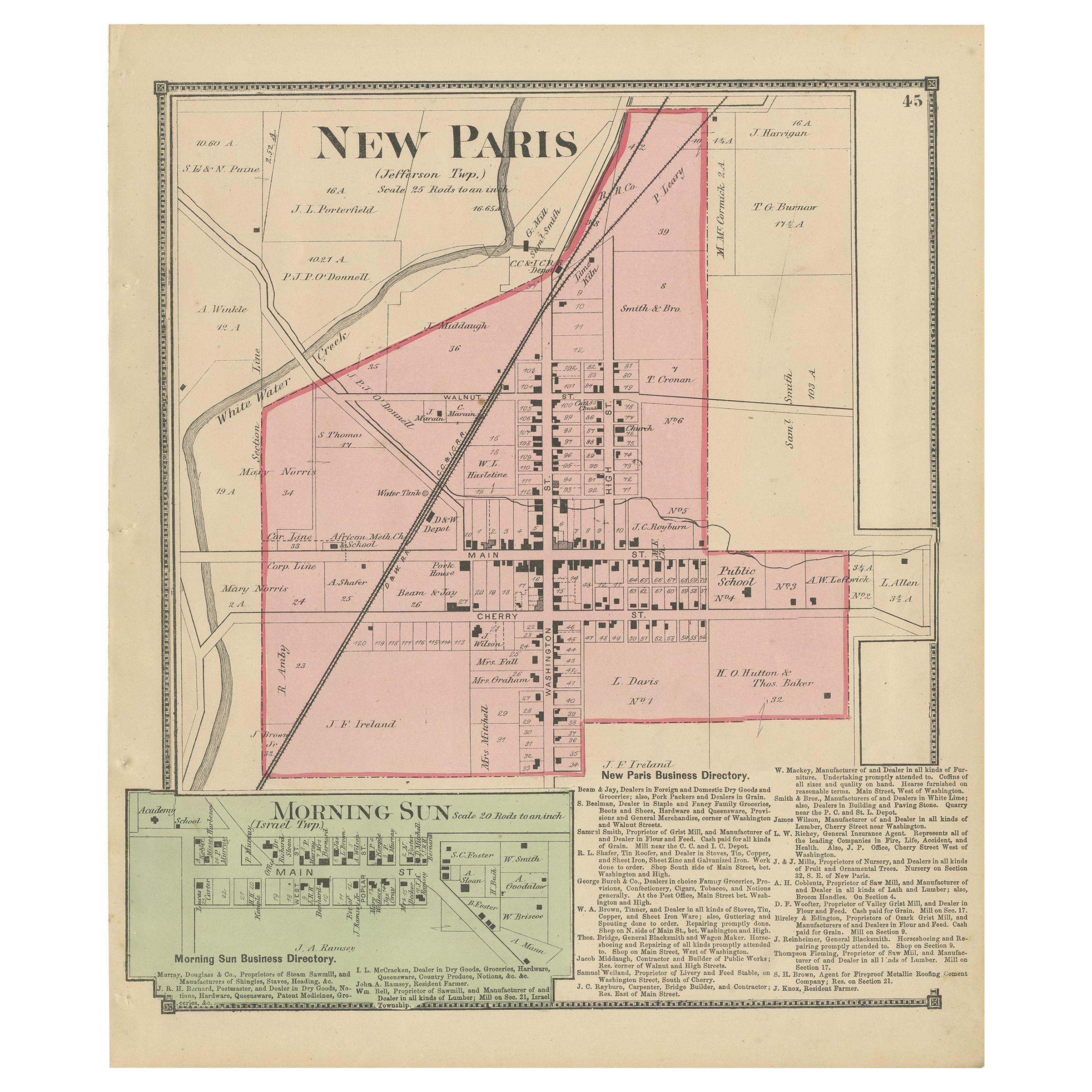
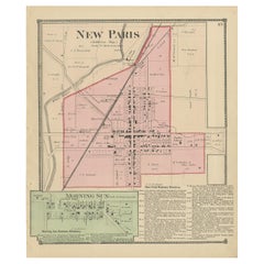
- Antique Map of New Paris and Morning Sun, 1871Located in Langweer, NLAntique map titled 'New Paris, Morning Sun'. Original antique map of villages and communities of Ohio. This map originates from 'Atlas of Preble County Ohio' by C.O. Titus. Published...Category
Antique Late 19th Century Maps
MaterialsPaper
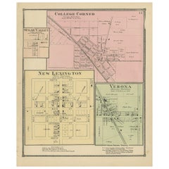
- Antique Map of College Corner, Sugar Valley, New Lexington & Verona '1871'Located in Langweer, NLAntique map titled 'College Corner, Sugar Valley, New Lexington, Verona'. Original antique map of villages and communities of Ohio. This map originates from 'Atlas of Preble County O...Category
Antique Late 19th Century Maps
MaterialsPaper
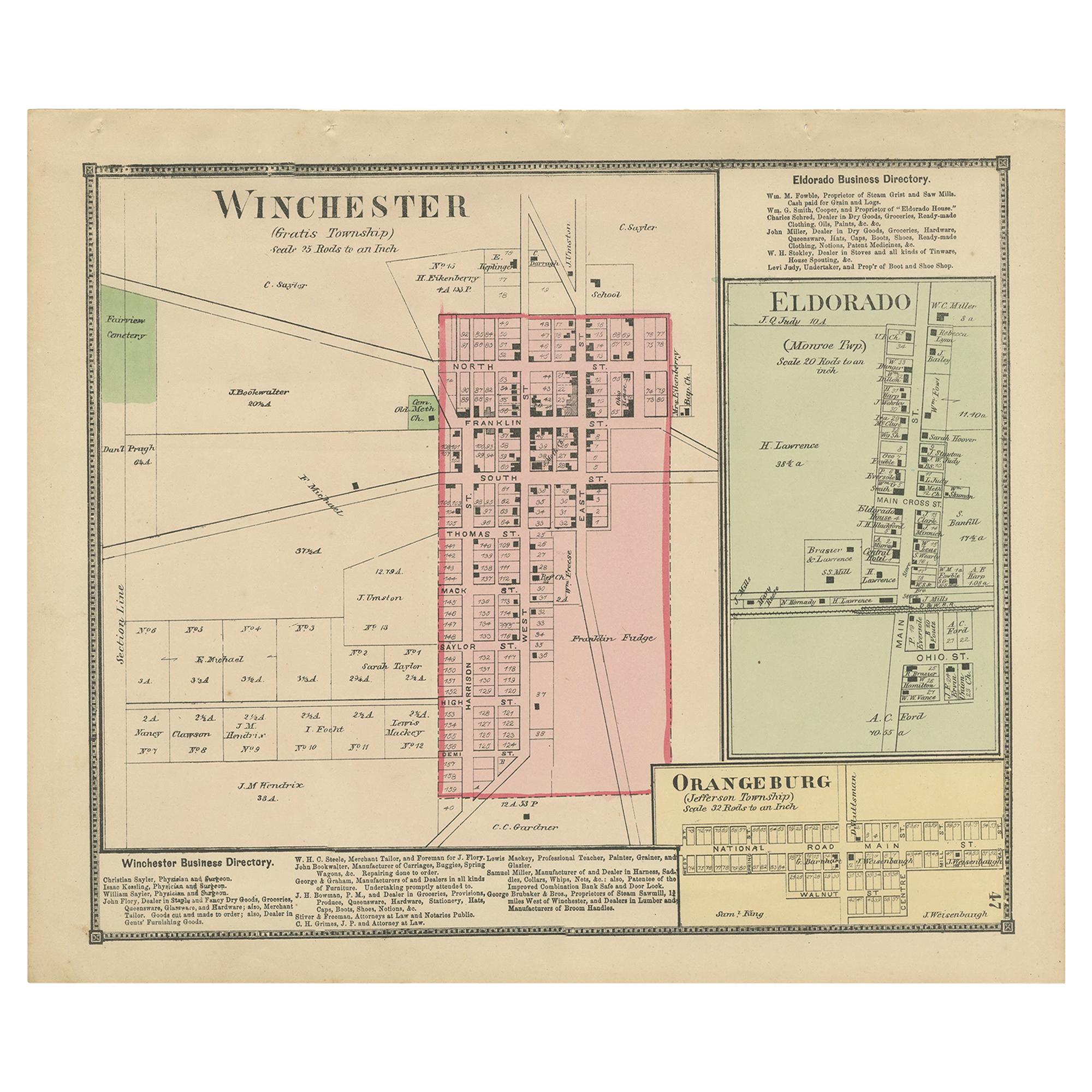
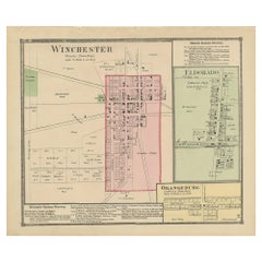
- Antique Map of Winchester, Eldorado & Orangeburg, 1871Located in Langweer, NLAntique map titled 'Winchester, Eldorado, Orangeburg'. Original antique map of villages and communities of Ohio. This map originates from 'Atlas of Preble County Ohio' by C.O. Titus....Category
Antique Late 19th Century Maps
MaterialsPaper
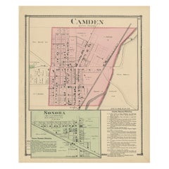
- Antique Map of Camden and Sonora, 1871Located in Langweer, NLAntique map titled 'Camden, Sonora'. Original antique map of villages and communities of Ohio. This map originates from 'Atlas of Preble County Ohio' by C.O. Titus. Published 1871.Category
Antique Late 19th Century Maps
MaterialsPaper
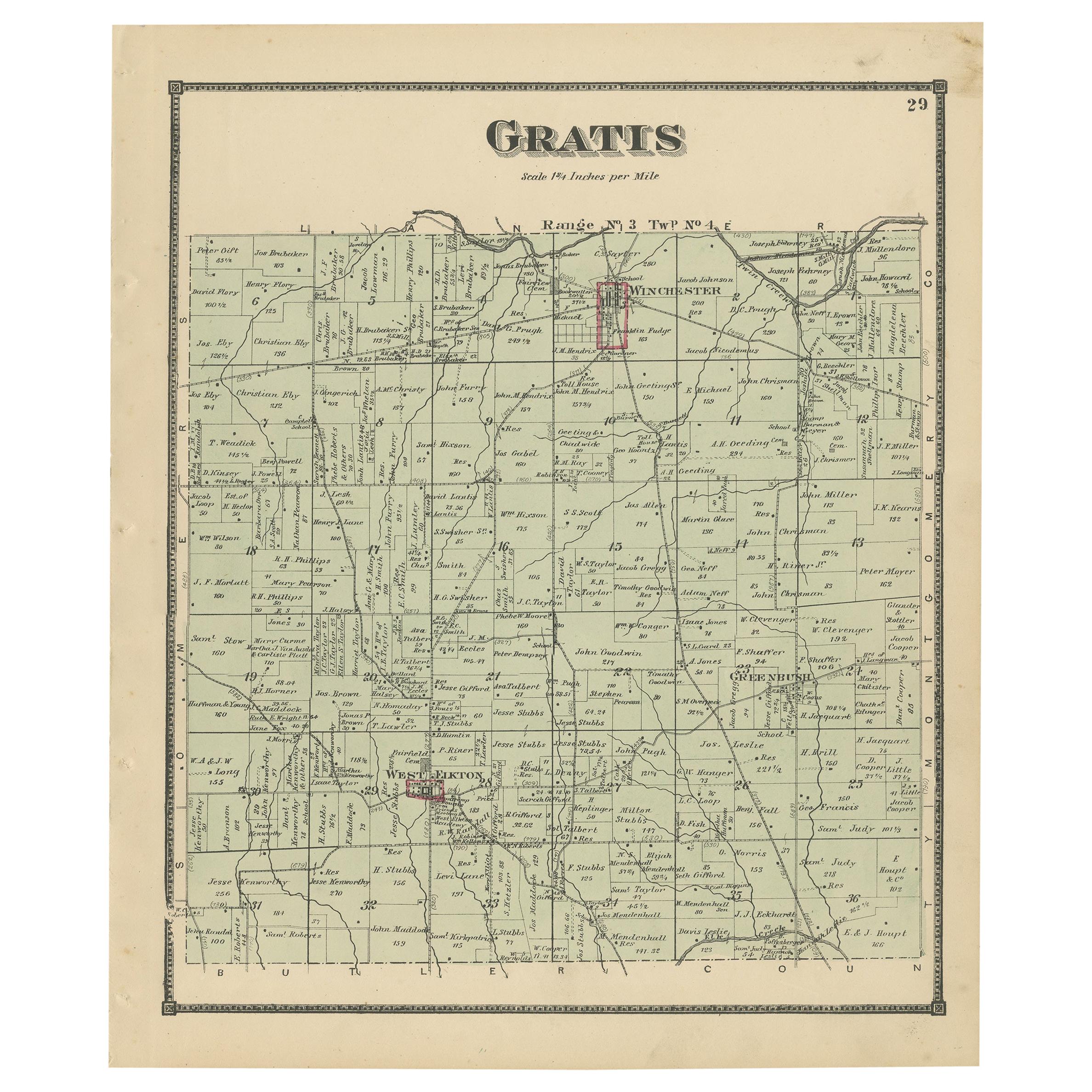
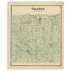
- Antique Map of Gratis 'Ohio' by Titus '1871'Located in Langweer, NLAntique map titled 'Gratis'. Original antique map of Gratis, Ohio. This map originates from 'Atlas of Preble County Ohio' by C.O. Titus. Published 1871.Category
Antique Late 19th Century Maps
MaterialsPaper
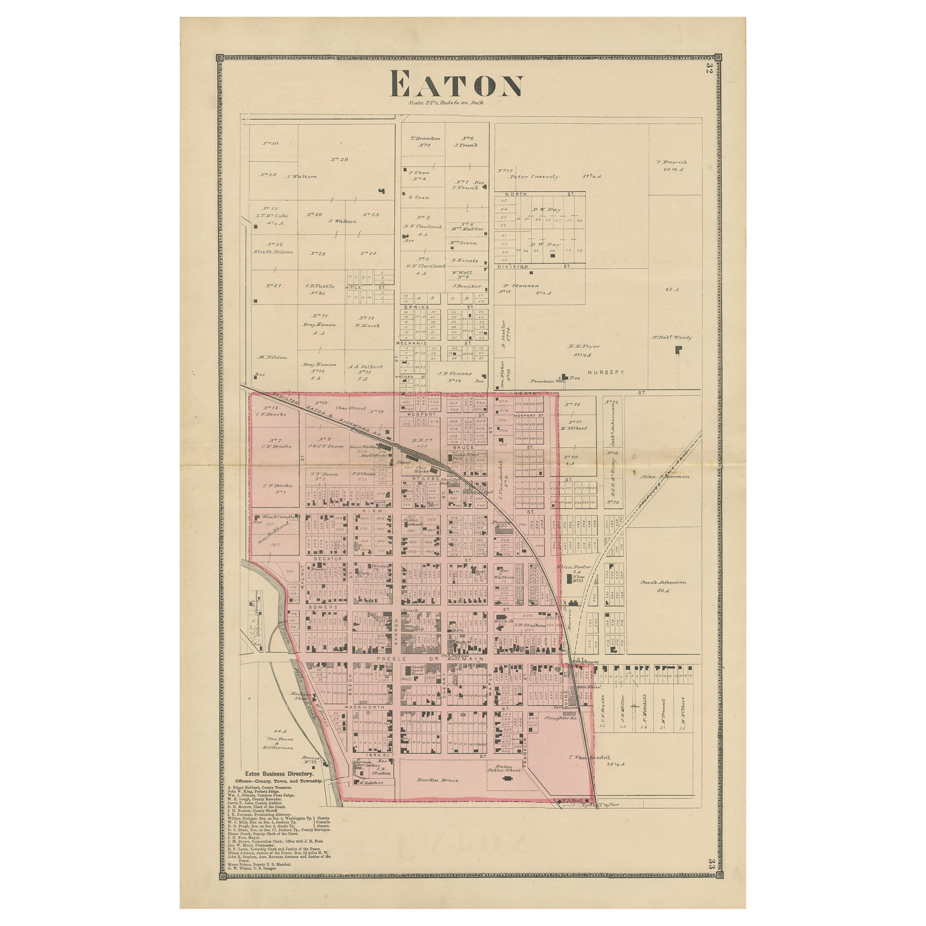
- Antique Map of Eaton 'Ohio' by Titus, 1871Located in Langweer, NLAntique map titled 'Eaton'. Original antique map of Eaton, Ohio. This map originates from 'Atlas of Preble County Ohio' by C.O. Titus. Published 1871.Category
Antique Late 19th Century Maps
MaterialsPaper

You May Also Like
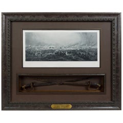
- 1876 "Gettysburg, The Repulse of Longstreet's Assault." EngravingLocated in Colorado Springs, COPresented here is an 1876 engraving of John B. Bachelder and James Walker’s Gettysburg. The Repulse of Longstreet’s Assault. The engraved scene depicts the decisive battle on the final day of the Battle of Gettysburg. Researched by the photographer and topographer John B. Bachelder and painted by James Walker, the original painting was created in 1870. This detailed engraving was done by H. B. Hall Jr. and published by James Drummond Ball. Otherwise called Pickett’s Charge, the battle occurred on July 3, 1863. Pickett’s corp commander, Lieutenant General James Longstreet was placed in charge of the attack despite his hesitations. Longstreet’s central role led to the title of the work, Repulse of Longstreet’s Assault. In an attempt to gain control of an important supply route, nine Confederate brigades charged across three-quarters of a mile of open ground against cannon fire to take Cemetery Ridge from the defending Union Army. Despite their overwhelming numbers, the Confederate forces were repelled with considerable casualties marking not only a decisive victory for the Union, but also the beginning of the slow defeat of Lee’s Army. The furthest the charging forces advanced before being repulsed would forever be known as the “High Water Mark of the Confederacy.” The Confederate army never recovered from the losses at Gettysburg and it effectively ended Lee’s campaign into Pennsylvania. The engraving gives the perspective from the Union rear, one that encompasses most of the battlefield, from Big Round Top on the left to the northern reaches of Cemetery Ridge on the right. The Confederate lines at Seminary Ridge are in the far distance, partially obscured by bursting shells. The image centers on the main Confederate assault, in the vicinity of what today are known as "The Copse" and "The Bloody Angle." The composition has elemen...Category
Antique 1870s American Prints
MaterialsPaper
- Antique Map of Principality of MonacoBy Antonio Vallardi EditoreLocated in Alessandria, PiemonteST/619 - "Old Geographical Atlas of Italy - Topographic map of ex-Principality of Monaco" - ediz Vallardi - Milano - A somewhat special edition ---Category
Antique Late 19th Century Italian Other Prints
MaterialsPaper
- Antique 1901 National Publishing Company's Road Map of New Jersey GeologicalLocated in Dayton, OHThe National Publishing Company's road map of New Jersey, showing all county and township divisions, cities villages and post-offices, railroads, ste...Category
Antique Early 1900s Victorian Prints
MaterialsPaper
- 1876 "Gettysburg. Repulse of Longstreet's Assault" with Union Officer SwordsLocated in Colorado Springs, COPresented here is an 1876 engraving of John B. Bachelder and James Walker’s Gettysburg. Repulse of Longstreet’s Assault together with two ornately decorated Union Officer swords...Category
Antique 1870s American Prints
MaterialsMetal
- Original Antique Map of India. C.1780Located in St Annes, LancashireGreat map of India Copper-plate engraving Published C.1780 Three small worm holes to right side of map and one bottom left corner Unframed.Category
Antique Early 1800s English Georgian Maps
MaterialsPaper

- Original Antique Map of Asia. C.1780Located in St Annes, LancashireGreat map of Asia Copper-plate engraving Published C.1780 Two small worm holes to right side of map Unframed.Category
Antique Early 1800s English Georgian Maps
MaterialsPaper


Recently Viewed
View AllMore Ways To Browse
Antique New Furniture
Antique Furniture Fair
New Hope Furniture
Antique Map New
Antique Map Fair
Used Furniture New Haven
Ohio Antique
Antique Furniture New Haven
Antique Ohio Maps
Antique Map Of Ohio
Map Of Ohio
1871 Atlas Of Preble County
Gettysburg Furniture
Amsterdam Map
Map Of England
Old Antique World Map
Old World Antique Maps
Antique European Map