Items Similar to Antique Map of Africa by Dufour, circa 1834


Want more images or videos?
Request additional images or videos from the seller
1 of 5
Antique Map of Africa by Dufour, circa 1834
About the Item
Antique map titled 'Afrique'. Uncommon map of Africa. Published by or after A.H. Dufour, circa 1834. Source unknown, to be determined.
- Dimensions:Height: 8.08 in (20.5 cm)Width: 10.24 in (26 cm)Depth: 0.02 in (0.5 mm)
- Materials and Techniques:
- Period:
- Date of Manufacture:1834
- Condition:General age-related toning, original folding lines. Blank verso, please study images carefully.
- Seller Location:Langweer, NL
- Reference Number:
About the Seller
5.0
Platinum Seller
These expertly vetted sellers are 1stDibs' most experienced sellers and are rated highest by our customers.
Established in 2009
1stDibs seller since 2017
1,966 sales on 1stDibs
Typical response time: <1 hour
- ShippingRetrieving quote...Ships From: Langweer, Netherlands
- Return PolicyA return for this item may be initiated within 14 days of delivery.
More From This SellerView All
- Antique Map of Asia by Dufour, circa 1834Located in Langweer, NLAntique map titled 'Asie par A.H. Dufour'. Uncommon map of Asia. Published by or after A.H. Dufour, circa 1834. Source unknown, to be determined.Category
Antique Mid-19th Century Maps
MaterialsPaper
- Antique Map of North America by Dufour 'circa 1834'Located in Langweer, NLAntique map titled 'Amérique Septentrionale'. Uncommon map of North America. Published by or after A.H. Dufour, circa 1834. Source unknown, to be determined.Category
Antique Mid-19th Century Maps
MaterialsPaper
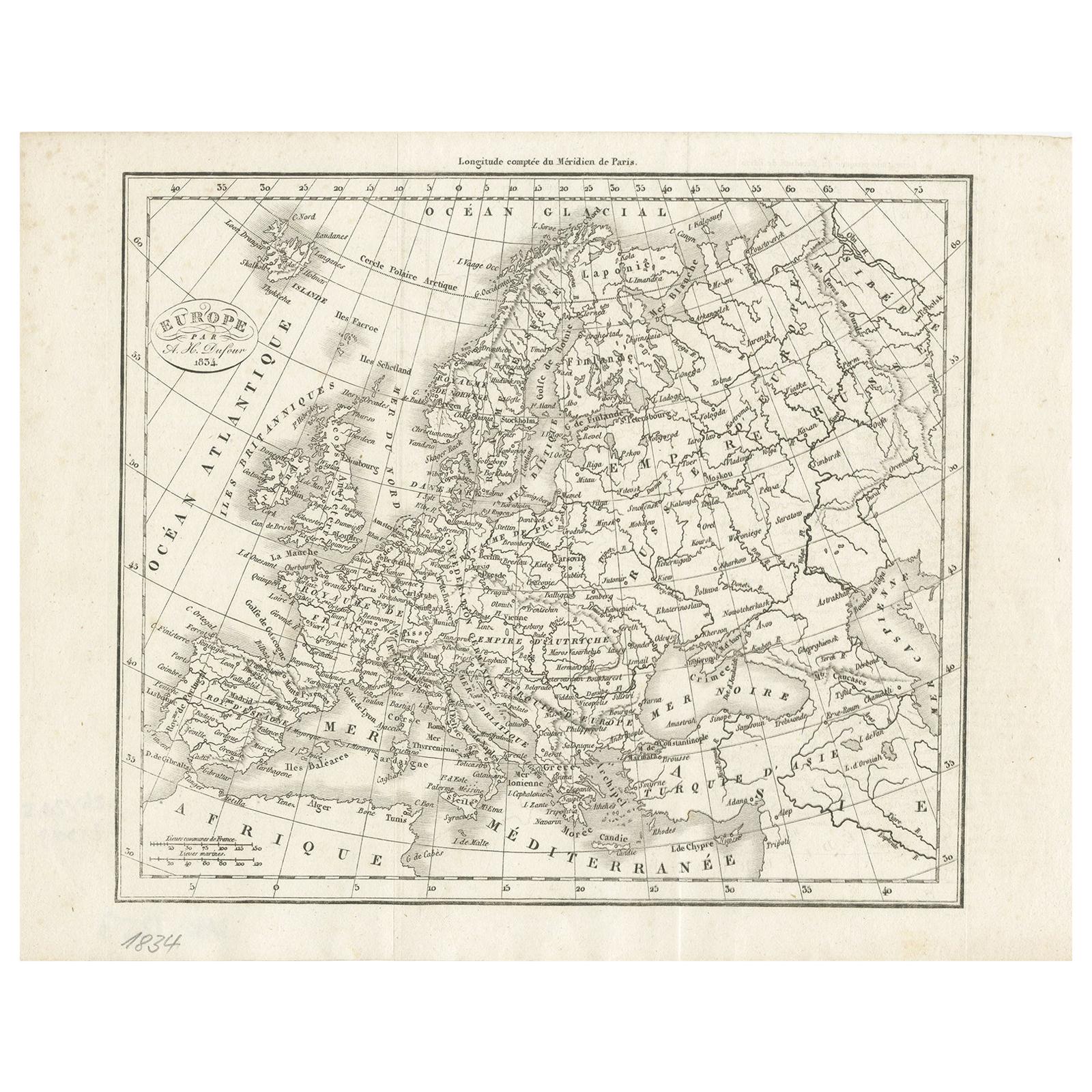
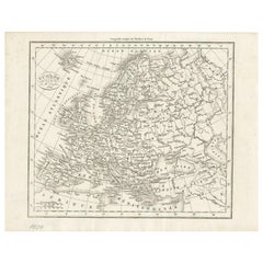
- Nice Decorative Black and White Small Antique Map of Europe, 'circa 1834'Located in Langweer, NLAntique French map titled 'Europe par A.H. Dufour'. Uncommon map of Europe. Published by or after A.H. Dufour, circa 1834. Source unknown, to be d...Category
Antique Mid-19th Century Maps
MaterialsPaper
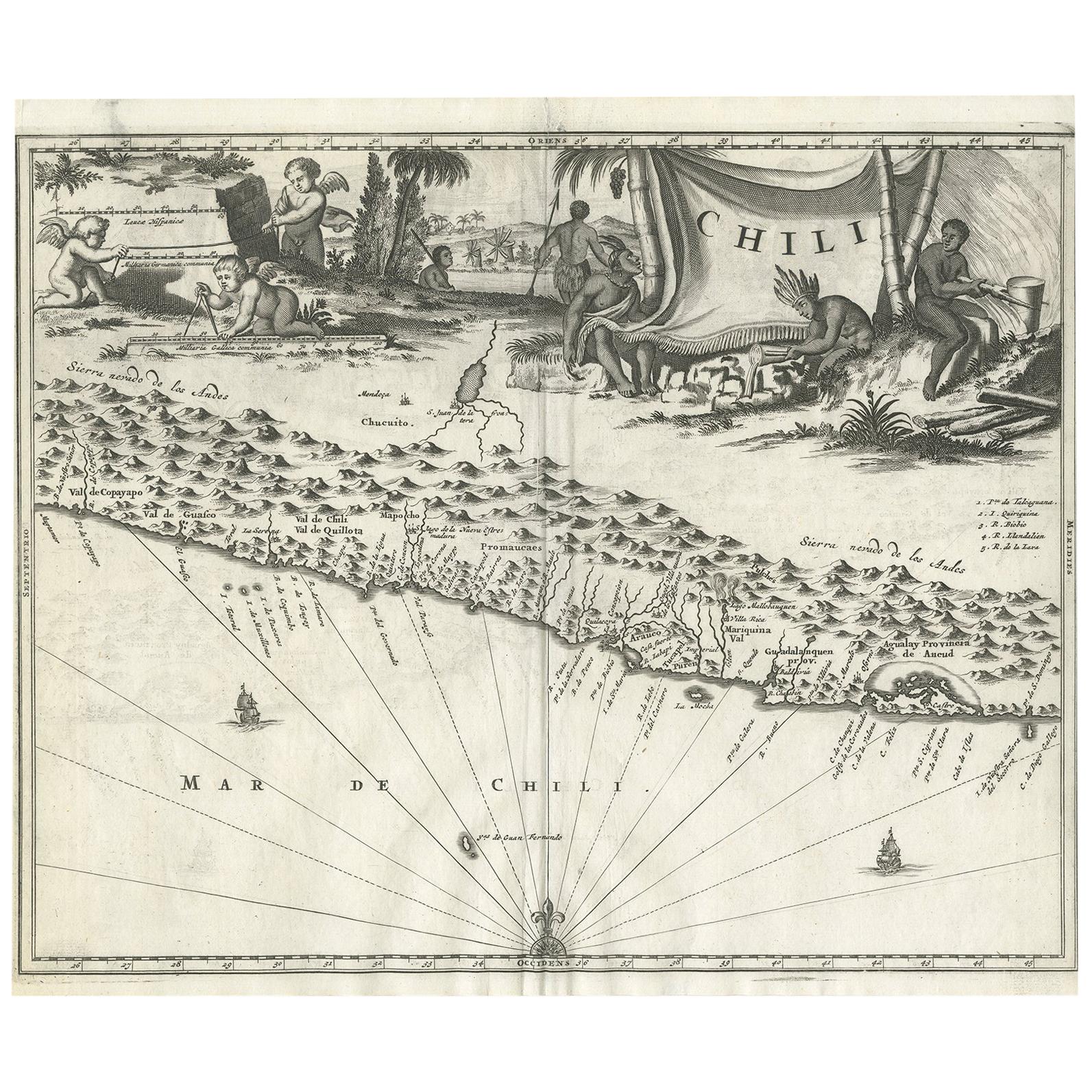
- Antique Map of Chili by Montanus, circa 1671By Arnoldus MontanusLocated in Langweer, NLAntique map titled 'Chili'. A very attractive map covering the known coastal region of Chile. The Andes are shown prominently, with two live volcanoes in the vicinity of Villarrica. ...Category
Antique Mid-17th Century Maps
MaterialsPaper
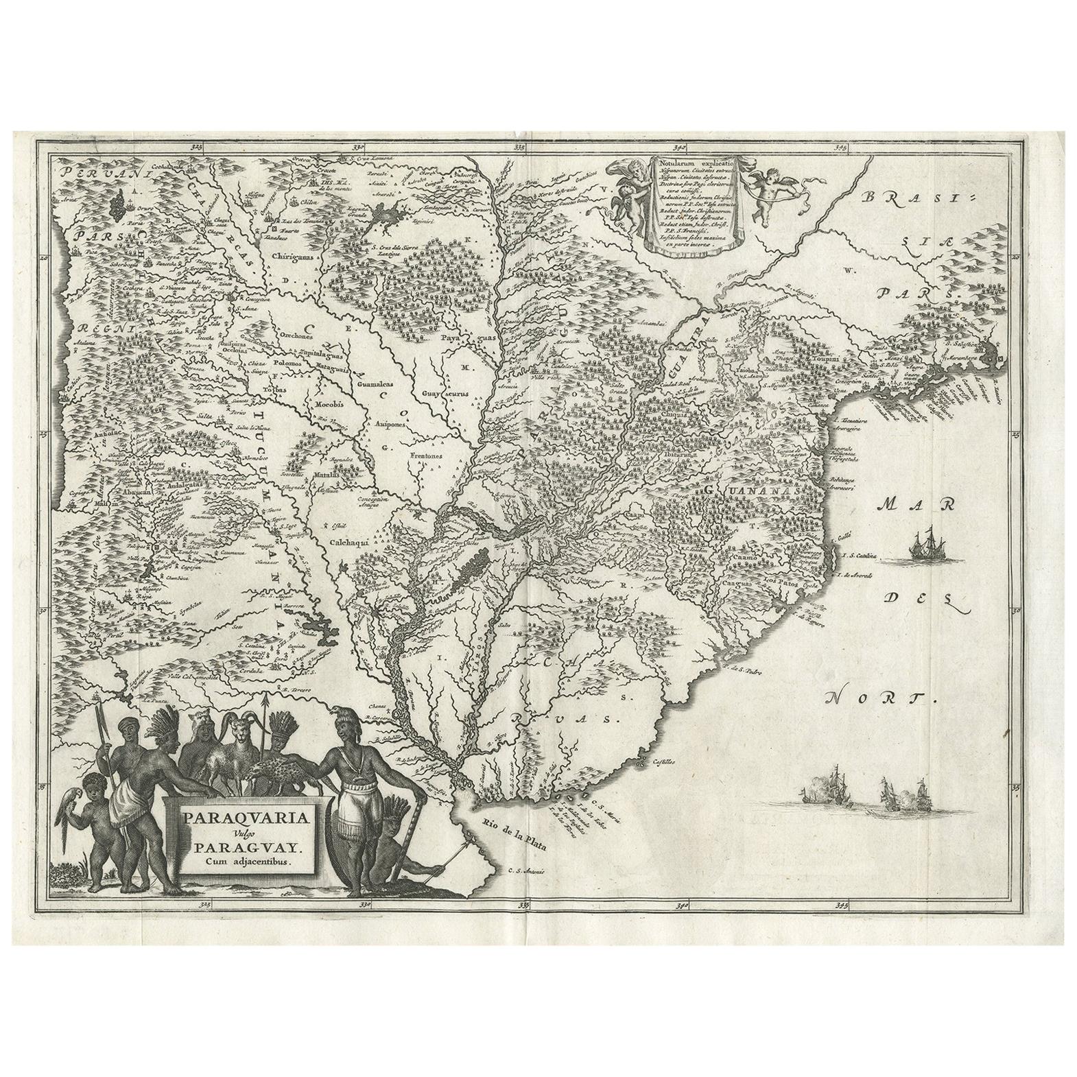
- Antique Map of Paraguay by A. Montanus, circa 1671By Arnoldus MontanusLocated in Langweer, NLAntique map titled 'Paraquaria Vulgo Paraguay Cum adjacentibus'. Antique map extending from Rio de Janiero to the Rio de la Plata basin. The map include...Category
Antique Mid-17th Century Maps
MaterialsPaper
- Antique Map of South America by Wyld, circa 1850By J. WyldLocated in Langweer, NLBeautiful folding map of South America titled 'Colombia Prima or South America Drawn from the Large Map in Eight Sheets by Louis Stanislas D ' Arcy Delarochette'. Three insets in the...Category
Antique Mid-19th Century British Maps
MaterialsPaper


You May Also Like
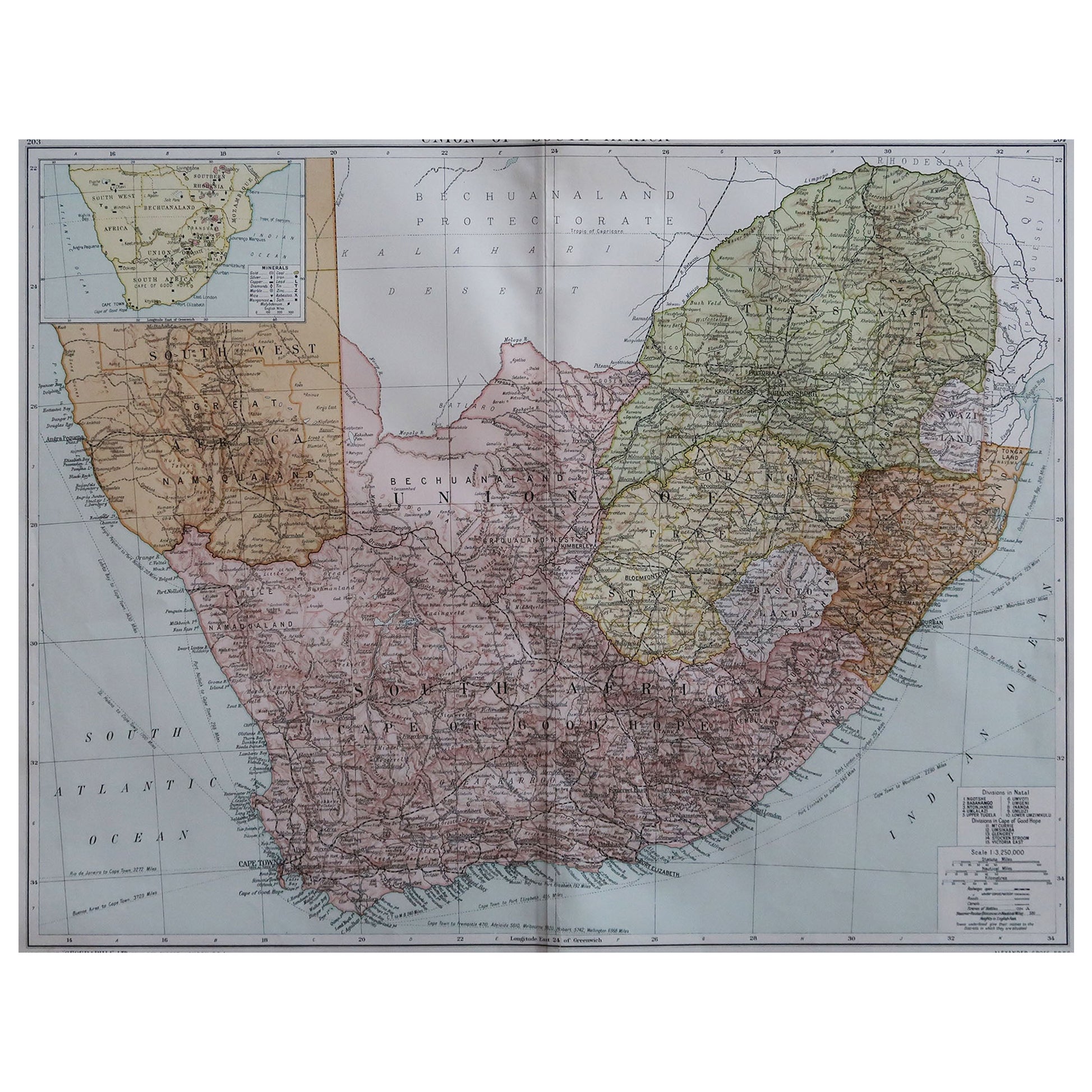
- Large Original Vintage Map of South Africa, circa 1920Located in St Annes, LancashireGreat map of South Africa Original color. Good condition / repair to a minor edge tear middle bottom Published by Alexander Gross Unframed. ...Category
Vintage 1920s English Edwardian Maps
MaterialsPaper
- London 1744 Published Watercolour Antique Map of East Africa by Eman BowenLocated in GBWe are delighted to offer for sale this New and Accurate Map of Nubia & Abissinia, together with all the Kingdoms Tributary Thereto, and bordering upon them published in 1744 by Emanuel Bowen This is a decorative antique engraved map of East Africa...Category
Antique 1740s English George III Maps
MaterialsPaper
- Original Antique Map of Cyprus. Circa 1880Located in St Annes, LancashireGreat map of Cyprus Drawn and Engraved by R.Walker Published W.Mackenzie, London Original colour Unframed.Category
Antique 1880s English Maps
MaterialsPaper
- Large Original Antique Map of Arkansas by Rand McNally, circa 1900By Rand McNally & Co.Located in St Annes, LancashireFabulous monochrome map with red outline color Original color By Rand, McNally & Co. Published, circa 1900 Unframed Minor edge tears.Category
Antique Early 1900s American Edwardian Maps
MaterialsPaper
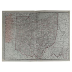
- Large Original Antique Map of Ohio by Rand McNally, circa 1900By Rand McNally & Co.Located in St Annes, LancashireFabulous monochrome map with red outline color Original color By Rand, McNally & Co. Published, circa 1900 Unframed Repairs to minor edge tears.Category
Antique Early 1900s American Edwardian Maps
MaterialsPaper
- Original Antique Map of South Dakota by Rand McNally, circa 1900By Rand McNally & Co.Located in St Annes, LancashireFabulous monochrome map with red outline color Original color By Rand, McNally & Co. Published, circa 1900 Unframed Minor edge tears.Category
Antique Early 1900s American Edwardian Maps
MaterialsPaper


Recently Viewed
View AllMore Ways To Browse
African Collectables
Africa Map
Map Of Africa
Antique Africa Maps
Antique African Maps
Antique Map Africa
Antique Map Of Africa
Antique Maps Of Africa
19th Century Africa Collectibles
Afrique Antique
19th Century Map Of Africa
Antique Geography
Antique World Atlas
Folding Maps
Antique Map Of Holland
Antique Maps Of Holland
Antique Furniture Plans
Map Plate