Items Similar to Antique Bible Map of the Middle East by A. Schut, 1743


Want more images or videos?
Request additional images or videos from the seller
1 of 6
Antique Bible Map of the Middle East by A. Schut, 1743
About the Item
Antique map titled 'De Gelegentheyt van 't Paradys en 't Landt Canaan'. Dutch Bible map covering the region between the Mediterranean and the Persian Gulf, featuring the Garden of Eden, which is located near "Babel". The map includes tiny engravings of Eve offering Adam the apple and the expulsion from the garden. Abraham's journey from Ur is noted, as are the wanderings of the Children of Isreal, and a vignette of Jonas and the whale.
This map originates from ‘Biblia Sacra, dat is, de H. Schriftuer van het Oude, en het Nieuwe Testament, naer de laetste Roomsche keure der gemeine Latijnsche overzettinge, in nederduitsch vertaeld (...)’ Utrecht, Hermanus Besseling, 1743.
- Dimensions:Height: 15.36 in (39 cm)Width: 21.19 in (53.8 cm)Depth: 0.02 in (0.5 mm)
- Materials and Techniques:
- Period:
- Date of Manufacture:1743
- Condition:Please study image carefully.
- Seller Location:Langweer, NL
- Reference Number:
About the Seller
5.0
Platinum Seller
These expertly vetted sellers are 1stDibs' most experienced sellers and are rated highest by our customers.
Established in 2009
1stDibs seller since 2017
1,965 sales on 1stDibs
Typical response time: <1 hour
- ShippingRetrieving quote...Ships From: Langweer, Netherlands
- Return PolicyA return for this item may be initiated within 14 days of delivery.
More From This SellerView All
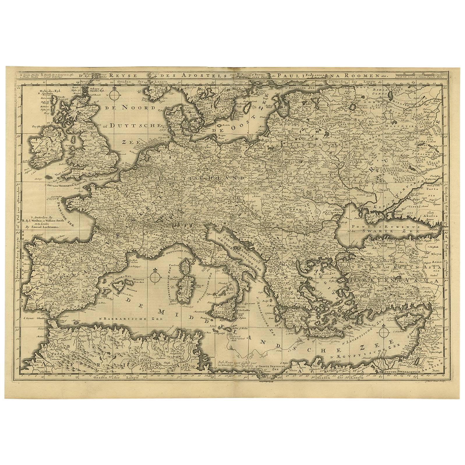
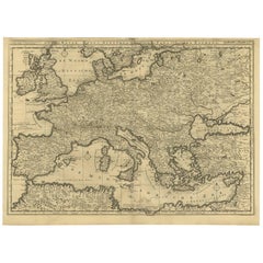
- Rare Antique Bible Map of Southern Europe by A. Schut, 1743Located in Langweer, NLAntique map of the Mediterranean and a large part of Europe, illustrating the voyage of St. Paul to Rome. This map originates from ‘Biblia Sacra, dat is, de H. Schriftuer van het Oud...Category
Antique Mid-18th Century Maps
MaterialsPaper
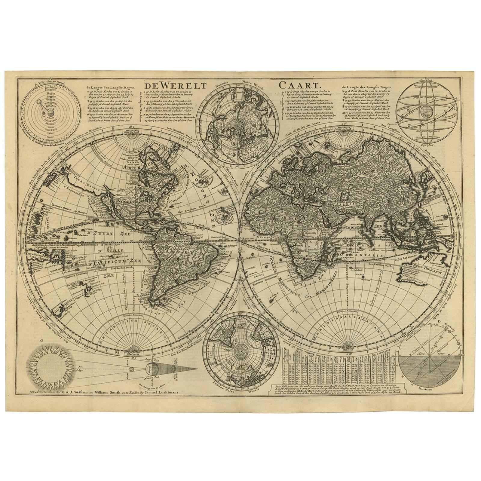
- Antique Bible World Map by R. & J. Wetstein, 1743Located in Langweer, NLAntique world map titled 'De Werelt Caart'. A scarce and richly detailed double hemisphere world map that was probably based on an earlier work by Cornelis Dankerts. This map has t...Category
Antique Mid-18th Century Maps
MaterialsPaper

- Rare Antique Map of the Middle East, ca.1690Located in Langweer, NLDescription: Antique print, untitled. Two decorative maps on one sheet of the middle east in biblical times. Source unknown, to be determined. Artists and Engravers: Anonymous...Category
Antique 1690s Prints
MaterialsPaper
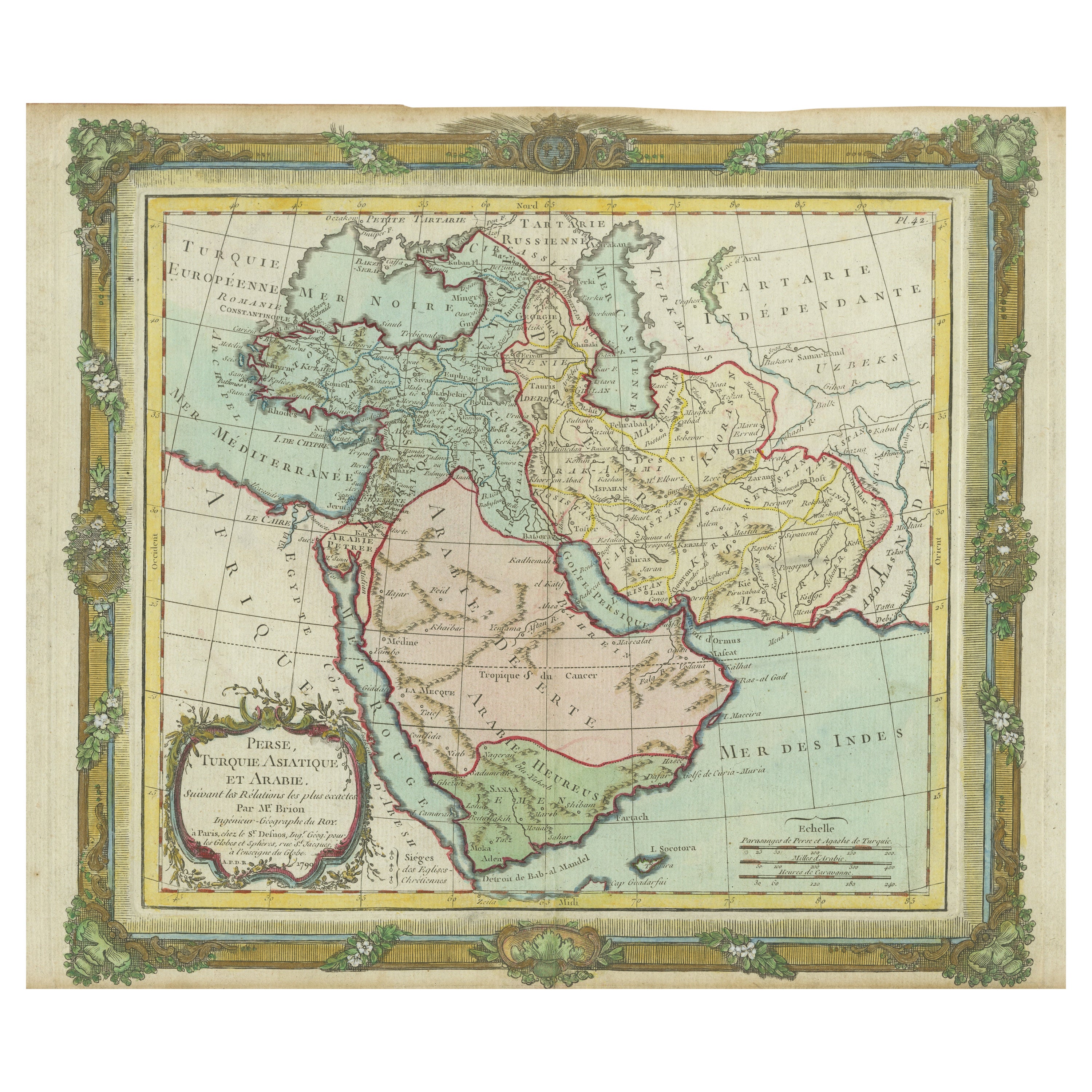
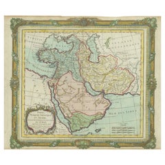
- Antique Map of the Middle East with a Large Arabia, 1799Located in Langweer, NLAntique map titled 'Perse, Turquie Asiatique et Arabie (..)'. Map of the Middle East with a large Arabia, extending from the Black Sea to the In...Category
Antique Late 18th Century Maps
MaterialsPaper
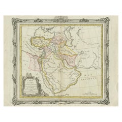
- Antique Map of the Middle East by Brion de la Tour '1772'Located in Langweer, NLAntique map titled 'Carte des Pays et Principaux Lieux (..)'. Original antique map of Middle East, extending to the Red Sea, Egypt, the Eastern Medi...Category
Antique Late 18th Century Maps
MaterialsPaper
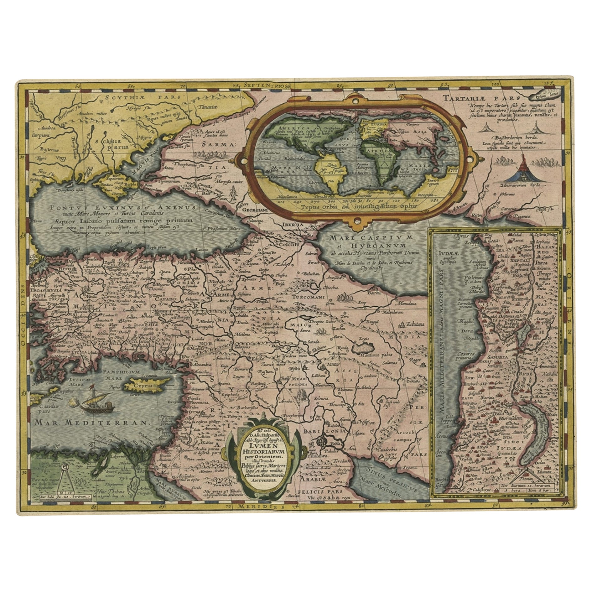
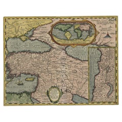
- Scarce Antique Map of the Middle East, Surrounded by Latin Text, 1624Located in Langweer, NLAntique map titled 'Lumen Historium per Orientem (..).' Scarce map of the Middle East, surrounded by Latin text. The two insets show Israel and an oval world map. This map (from the last edition of Ortelius Theatri Orbis Terrarum Parergon, 1624) was engraved by Franciscus Hareio. Later, this map was copied by Hornius for his World Atlas (1653). Artists and Engravers: Franciscus Haraeus (Latinised form of Franciscus Verhaer; also known as Frans Verhaer), (Utrecht 1555? - Leuven, 11 January 1631), was a Dutch theologian, historian, and cartographer. He is best known for his history (from a Catholic point of view) of the Dutch Revolt...Category
Antique 1620s Maps
MaterialsPaper

You May Also Like
- Original Antique Map of South East Asia by Becker, circa 1840Located in St Annes, LancashireGreat map of South East Asia Steel engraving with original color outline Engraved by Becker Published by Virtue, circa 1840. Unframed.Category
Antique 1840s English Other Maps
MaterialsPaper
- Original Antique Map of South East Asia by Thomas Clerk, 1817Located in St Annes, LancashireGreat map of South East Asia Copper-plate engraving Drawn and engraved by Thomas Clerk, Edinburgh. Published by Mackenzie And Dent, 1817 Unframed.Category
Antique 1810s English Maps
MaterialsPaper
- Original Antique Map of South East Asia, Arrowsmith, 1820Located in St Annes, LancashireGreat map of South East Asia Drawn under the direction of Arrowsmith Copper-plate engraving Published by Longman, Hurst, Rees, Orme and Brown, 1820 Unframed.Category
Antique 1820s English Maps
MaterialsPaper
- Original Antique English County Map, East Yorkshire, J & C Walker, 1851Located in St Annes, LancashireGreat map of The East Riding of Yorkshire Original colour By J & C Walker Published by Longman, Rees, Orme, Brown & Co. 1851 Unframed.Category
Antique 1850s English Other Maps
MaterialsPaper
- Original Antique Map of The World by Thomas Clerk, 1817Located in St Annes, LancashireGreat map of The Eastern and Western Hemispheres On 2 sheets Copper-plate engraving Drawn and engraved by Thomas Clerk, Edinburgh. Published by Mackenzie And Dent, 1817 ...Category
Antique 1810s English Maps
MaterialsPaper
- Original Antique Map of The Netherlands, Engraved by Barlow, Dated 1807Located in St Annes, LancashireGreat map of Netherlands Copper-plate engraving by Barlow Published by Brightly & Kinnersly, Bungay, Suffolk. Dated 1807 Unframed.Category
Antique Early 1800s English Maps
MaterialsPaper


Recently Viewed
View AllMore Ways To Browse
Middle East Furniture
18th Century Bible
Persian Engraving
Van Apple
Eve Apple
Persian Gulf
Mediterranean Eden
Whale Engraving
Antique Furniture Dundee
Antique Map Chicago
Antique Map Copenhagen
Antique Map Malta
Antique Map Of Malta
Antique Maps Of Malta
Antique Maps Of Pennsylvania
Antique Queensland
Mitchell Antique Maps
North Carolina Map